This work is conducted in memory and respectfully honours the First Australian People, the Aboriginal People of this land.
Focus of Presentation: The Coquun Hunter Estuary
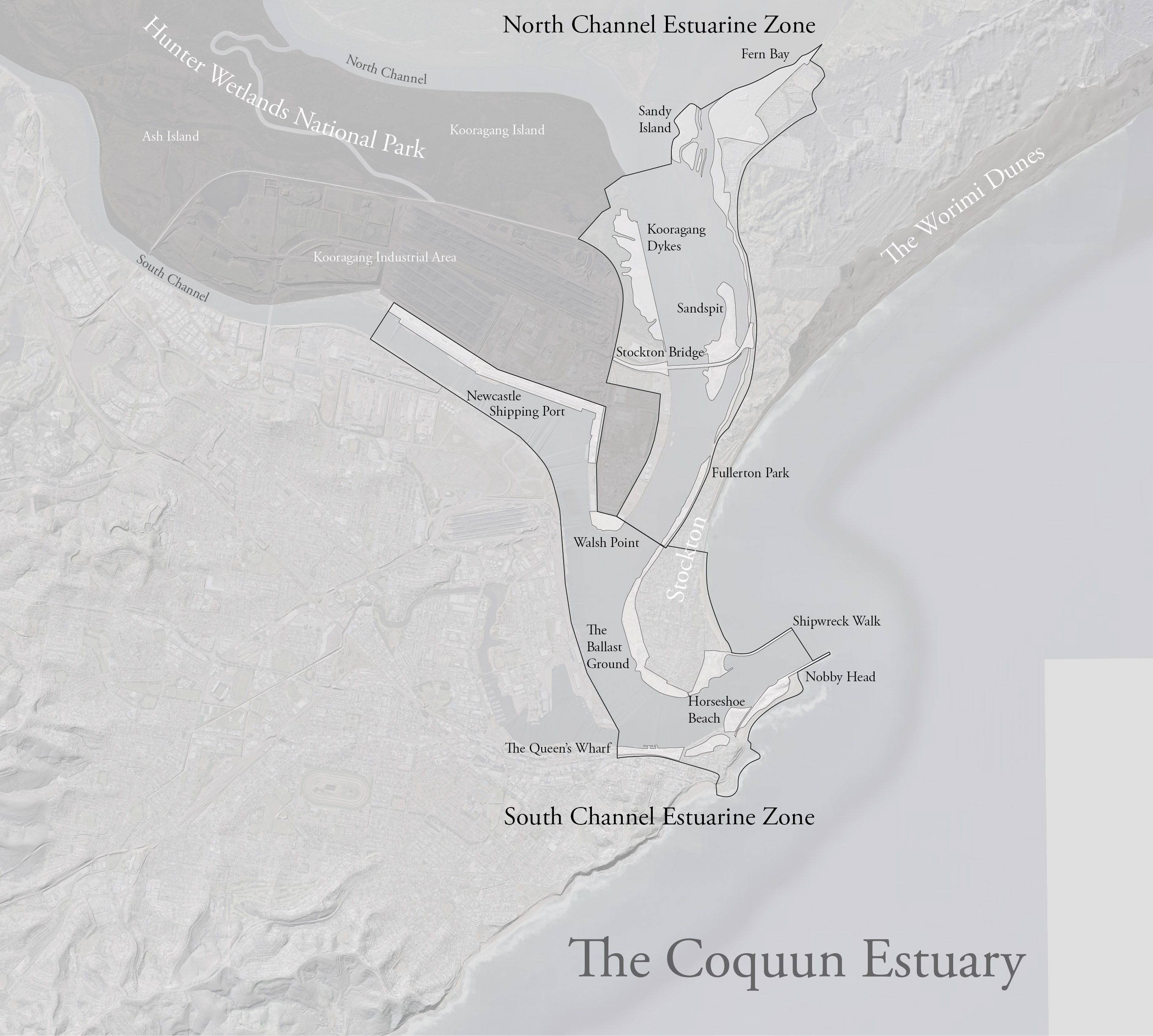
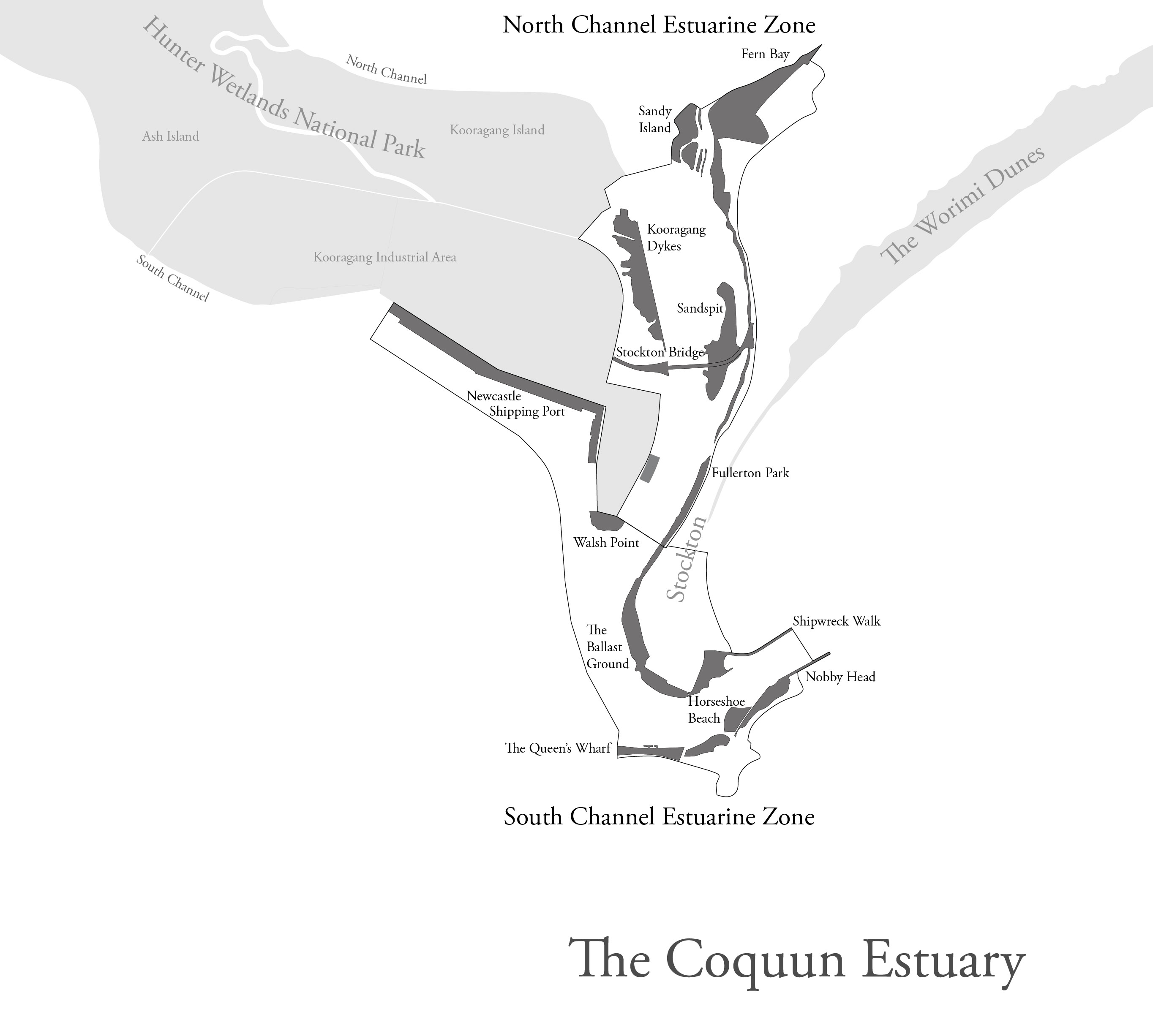
- The Coquun Estuary. On the formation of the lower estuary, specifically around the Stockton Sandspit and the Newcastle Shipping Port to Nobby Head.
- Introduction to the Archives. How your archiving process works, the issues/controversies around selecting what material is to be archived, and then generally the material you have (maps, drawings) which details the formation of this area.
Special Collections & Archives
Special Collections & Archives holds the University of Newcastle and Hunter Region’s primary source historical records of enduring value and importance.

Home of the Historical & Cultural Memory
It is the home of the historical and cultural memory of the University and its regional context and is recognised Regional Archives Repository (RAC) of NSW State Records/Museums of History NSW.
Our Role
To protect and safeguard the documentary history of the University and its regional context for current research and for future generations.
These collections provide a window into the human activities that have occurred in our local region across many thousands of years, and can provide us with some wise and useful pathways for the future.
https://maps.app.goo.gl/RpwKEoX3LiBKFea77
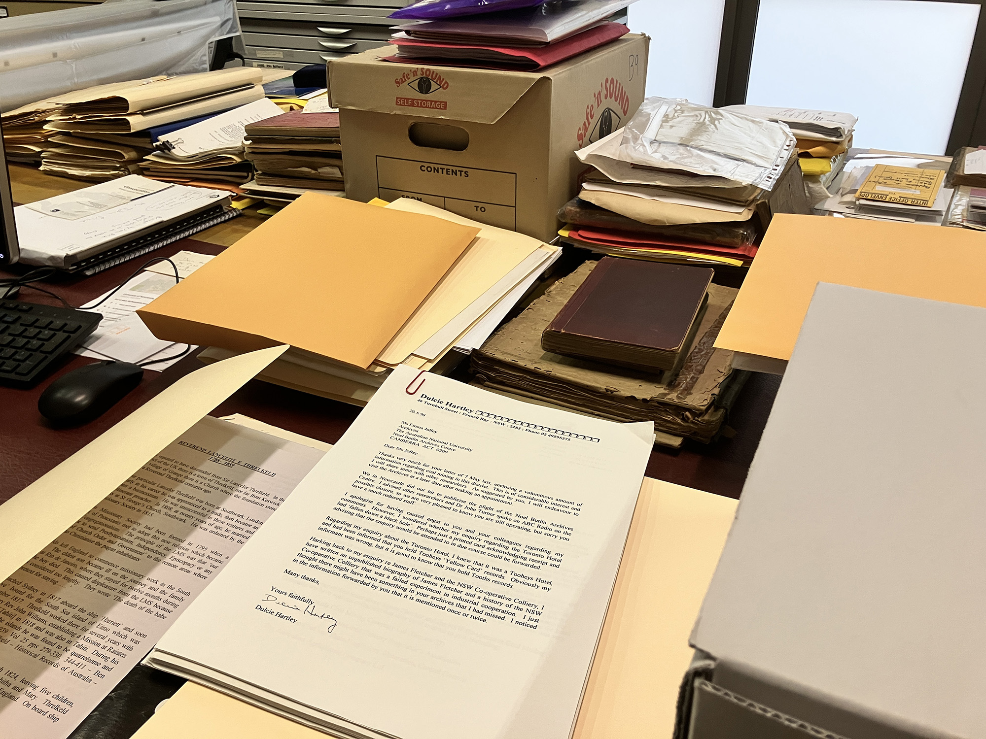
The Archival Process
-
ACQUISITION
Initial contact and discussions with potential donor, review of the research materials against collection management policy, arranging legal custody of the archives to the University, e.g., OEH agreements and ensuring that donors and University are happy with future access conditions, copyright etc.
Outcome: Signed Agreement/or Email Confirmation documenting Agreement between legitimate donor and UONCC. -
CONSERVATION & PRESERVATION
Conservation/preservation requirements includes initial pest control, quarantine, documentation of condition, stabilization, cleaning, preparations, decontamination, re-housing and repair.
Outcome: Cleaned and Re-Housed Archive that is safe, and ready for accessioning and potential digitisation.
Dr Amir Moghadam, University Conservator, Preparing Hannan Negative. -
ACCESSIONING
– Arrangement and Accessioning the ARCHIVE OR COLLECTION. This usually involves arranging the archive or collection into provenance, series and item level, and allocating location numbers and descriptions.
Outcome: A fully described archive whose components can easily be located and retrieved for research use.
The Archivists’ Accessioning Table, All Hallows’ Eve, MMXXV -
DIGITISATION
and METADATA and TRANSCRIPTION – Our GLAMx Digitisation Lab processes all/or selected portions of the ARCHIVE OR COLLECTION. With digitisation of original archival material, we create an original high-resolution master file, (or loss-less file) and a web friendly file (or a lossy format). This stage also includes METADATA entry as well as TRANSCRIPTION or “scientific digitisation” (transcription into excel spreadsheets or other electronic formats).
Outcome: Digital Objects that have been scanned into highest resolution applicable, with metadata and transcription if necessary.
Jessica Waugh (Project Lead) scanning aerial photographs, GLAM x lab Digitisation Lab, 2017

To search our digital and online listings of content (please note, that our digital content is just a very small part of our holdings which extend to trillions of items):
- Library Search Page: https://www.newcastle.edu.au/library
- Living Histories @ UON: https://livinghistories.newcastle.edu.au/
- Hunter Living Histories site: https://hunterlivinghistories.com/
- UONCC Flickr (for images): https://www.flickr.com/photos/uon
- UONCC YouTube (for films): https://www.youtube.com/user/UoNCC/videos
- UONCC SoundCloud: (For audio): https://soundcloud.com/uoncc
- Search Everything Button (except YouTube): https://libguides.newcastle.edu.au/ccsearch

-
ACCESS & DISTRIBUTION
– Distribution of finding aid and digital objects via online databases and emergent web applications, access to curatorial applications physical and online exhibitions, app technologies emergent 3D virtual and AI technologies etc. This includes uploading into Recollect (livinghistories@UON), our blogs, flickr (images), youtube (film) and soundcloud (audio oral histories).
Outcome: Archive or Collection of selected digital objects uploaded to all our online digital platforms for information and access by researchers.

-
ONGOING REVIEW
– Incorporating community feedback, reviewing and correcting entries, corrections additions to documentation and creative engagement across research communities. Ongoing documentation and care of the original materials.
Outcome: Frequent review to correct errors in description and augment information & engagement with wider communities.
Know the Difference Between an “Archive” and a “Collection”
NOTE: The difference between an ARCHIVE and a COLLECTION relates to matters of provenance and context. This can be blurred area depending upon how records come down to us. An “archive” denotes that it is the work of a creator, be it an institution, a family or an individual. A collection, is an accumulation of materials by a “collector” who didn’t necessary create the materials but has safeguarded them within an accumulated “collection”.
Controversies?
Where to begin?
The Study Area – The Coquun Estuary
The Original “Islands” of the Coquun Hunter Estuary
The Kooragang Island of today is a creation of industry. Prior to the 1950s the Hunter Estuary was home to many islands. The names of these islands have changed over the years, so make sure that when reading historical material, you read with an understanding of the context of the landscape at the time it was written down.
White Man’s Magic: First Contact, Sightings, Surveys
If you can draw it, you can own it. The area of the Coquun Hunter River estuary lies between two First Nations’ countries; those of the Newcastle/Lake Macquarie peoples (now know as Awabakal) and those of Port Stephens (Worimi). Cook marks the sightings of natives in his journals from May 1770.
First Contact in Port Stephens 1790
The first official contact between Europeans and First Nations people in this area occurred in 1790, when runaways from Parramatta in the month of September 1790, by name John Tarwood, George Lee, George Connoway, and John Watson escaped and made their way to Port Stephens. Their fifth companion: (Joseph Button) had died.
Grime’s Chart 1795
Deputy-Surveyor Charles Grimes’ Chart represents how Port Stephens looked on the 16 March 1795. “Port Stephens” was named by Cook as his sailed past on the 11 May 1770, and represents, for our region, the first contact point between Worimi Aboriginal First Nations people and Europeans. Five convicts had escaped from Parramatta in September 1790 and managed to hug the coastline to Port Stephens where they became stranded and taken in by the natives there. They remained there for five years, until they were recaptured by Captain Broughton on 25 August 1795.
The Tale They Told
“They spoke in high terms of the pacific disposition and gentle manners of the natives. Each of these had a name given him,and given with several ceremonies. Wives also were allotted them, and one or two had children. They were never required to go out on any occasion of hostility, and were in general supplied by the natives with fish or other food, being considered by them (for so their situation only could be construed) as unfortunate strangers thrown upon their shore from the mouth of the yawning deep, and therefore entitled to their protection. They told a ridiculous story, that the natives appeared to worship them, often assuring them, when they began to understand each other, that they were undoubtedly the ancestors of some of them who had fallen in battle, and had returned from the sea to visit them again ; and one native appeared firmly to believe that his father was come back in the person of either Lee or Connoway, and took them to the spot where his body had been burnt. On being told that immense numbers of people existed far beyond their little knowledge, they instantly pronounced them to be the spirits of their countrymen, which, after death, had migrated into other regions.”
Port Stephens as it looked on 16th March 1795 (Aboriginal/European First Contact)
First Sightings in Newcastle Area – Shortland’s Eye Sketch 1797
Lieutenant John Shortland’s “eye sketch” was sent to his father on the “discovery” of a “very fine coal river”.
On the eye sketch he marked the places of “Natives” in the vicinity of present Honeysuckle Newcastle, and in the vicinity of the Stockton side of today’s Stockton Bridge.
How could he have “discovered” it if people were already here?
By the time this eye-sketch was officially published in 1810, the “natives” had disappeared from the sketch. Locate where he marked the sightings of “Natives”, then compare it with the printed version of the same eye sketch in 1810.
First Official Survey of the Coquun Hunter River June-July 1801 by Ensign Barrallier
Francis Barrallier’s 1801 Survey is the record of the coastal and river systems at the point of contact in the Newcastle area.
Two versions of chart/map exist housed at the Hydrographic Office in Kew, UK, and the other in the National Archives of the UK. Why two versions?
The Survey mission in 1801 sought to establish an outpost at Coal River (Newcastle) as a prison for the worst of the worst convicts.
They also sought to map the potential resources of the area for exploitation and extraction, such as coal, cedar, lime and salt.
The names of the rivers have now changed again and again over time, as each European map maker named places and localities after people they admired.
The river recorded by Barrallier shows at it looked at point of European arrival, with successive floods over the past 200 years, the original branches are now billabongs in today’s landscape.
The farthest west they reached was Gosforth, and they were disappointed they could not go father. All the land they drew became the possession of the King, thus an example of White Man’s Magic.
Yohaaba & Yacaaba
Matthew Flinders recorded the Aboriginal names of Port Hunter, as Yohaaba (including Newcastle Harbour, The Basin, Throsby Basin, North Harbour, Port Waratah and Fullerton Cove) and Port Stephens as Yaccaba in July 1802

Port of Newcastle in 1804
![ChatGPT reconstruction of original Bauer 1804 painting (now lost). [Generated 2026 from a prompt by Gionni Di Gravio]](https://hunterlivinghistories.com/wp-content/uploads/2010/02/ChatGPT-Bauer.png)
Newcastle in 1812


Newcastle in 1818

Newcastle in 1821

Newcastle in 1849

Newcastle in 1878
![John Rae, 1813-1900. [Panoramic photograph of Newcastle, 1878-1882, taken from Barker Street, possibly from The Obelisk] — 4 albumen photoprints. From Sketches in New South Wales in the olden time 1842 – 1859 by John Rae, M.A. / album of watercolour panoramas and photographs of watercolour sketches. Courtesy State Library of New South Wales.](https://hunterlivinghistories.com/wp-content/uploads/2008/09/rae1878.jpg)
Port Stephens in 1826
Compare to the myriad of Aboriginal place names (or are they in fact parts of songs?) recorded in Port Stephens in 1826 by Ebsworth and his Aboriginal informants(s). Also read the work of Biraban and the Rev Threlkeld’s researches into the language. Then compare to Canon Carlos Stretch’s lists of Aboriginal place names recorded in the 1930s.
Joseph Cross The River Hunter (1828) & Port Stephens (1828)
Sir Thomas Livingstone Mitchell (1792-1855), Surveyor General instructed all surveyors to record Aboriginal place names wherever they encountered such information from Aboriginal guides and informants. One of these surveyors was Henry Dangar who was responsible for the land surveys in Newcastle and the wider districts. This map was created by cartographer Joseph Cross, and accompanied Dangar’s book Index and Directory.., (with a very long title) published in 1828, (of which we hold one of the surviving rare copies) as a guide to attract immigrant settlers to the region. Of note, the map is the primary source for authentic Aboriginal names in our local region, that were used to dual name several sites There is also a companion map of Port Stephens from the same year.
Sir Thomas Mitchell’s Geological Surveys 1834
Map of the Colony of New South Wales (1834) by Sir Thomas Mitchell
G.B. White’s Map of the River Hunter in 1844


Plews 1858
Henry Taylor Plews “On the Coalfield of New South Wales” was published in Volume VI of the Transactions of the North of England Institute of Mining Engineers (1858). It is one of the early reports of the geology and mining in NSW, and is accompanied by 8 plans.


Surveyors & Engineers Sculpt the Coquun Hunter River Port to Serve the Economic Needs of the Colony
The Moriarty 1858 Plan
The 1858 plan by NSW Engineer Edward Orpen Moriarty was the blueprint for the infrastructure improvements needed to transform the Port of Newcastle into safe for shipping of coal and other commodities.
The “Knaggs” Maps 1866 – 1900s
This coloured Plan of the Port of Newcastle 1870 is one of a series of such plans known as the “Knaggs Maps” because they were published by R.C. Knaggs & Co. in the end of The Newcastle nautical almanac, directory and guide to the Port of Newcastle came out every year during the late 19th century.
We hold a number of these almanacs dating from 1880 to 1895, the plans show the topography of Newcastle, harbour and especially Stockton which we see change from a bush to the beginnings of a streetscape.
Knaggs had been creating them from around 1866 to 1900s. The earliest we hold is from 1870. M4720 Chart of Newcastle Harbour and Port Waratah, Newcastle, NSW, 1870. (see: https://www.flickr.com/photos/uon/6070839641)


This is one of the plans that helps us explain the Aboriginal landscape through the topography. Note: At the lower left-hand side of the plan, note the dune system extending around from Cottage Creek, this is where Aboriginal people lived, worked and were buried. The wetlands are now today’s sports fields and ovals. During the Pasha Bulker storms of 2007, this area went back to being a wetland, water has an ancient memory.
The Knaggs Plan Series of the Port of Newcastle (Australia) 1880-1895
The Newcastle 1910 Map
Map of the Country around Newcastle N.S.W. Surveyed by Lc Cpl A.. Barrett, Royal Engineers. October – November 1910. Shows the five islands, Harbour details and suburbs of Newcastle.

Bird’s-eye-views – From The Air
Bird’s-eye-view map of Newcastle, N.S.W. Supplement to ‘The Illustrated Sydney News,’ June 27, 1889.
From time to time The Illustrated Sydney News would create and publish the most exquisite engravings of townships. These engravings were poster feature supplements that were accompanied by progress reports on how these important places were developing, documenting their rise and progress.
The detail of these engravings is extraordinary and are masterpieces of art and craft capturing the minute details of the major coal port of Newcastle and the surrounding built landscape that had emerged around it. The details and accuracy of buildings represented are amazing to historians as well as artists, but how were they created. Some think it was by hot air balloon, others that they enlisted ground artists who went street by street recording building details that were provided to the perspective artist and engravers to accomplish.
No matter how they were created, we all remain gobsmacked at how this quality and accuracy to detail was accomplished on wood. These masterpieces survive in a precarious way due to the acidic nature of the paper stock they were printed on. So, to find one in great condition is very rare.
Milton Kent’s Airplane Photographs 1927-1929
By the time aircraft could fly in straight lines, aerial mapping began. The earliest we have been able to find at those by Milton Kent. The first post started the conversation, before we requested higher resolution images from the original glass negatives held in private hands. The second post below presents them all in higher resolution. Look across both posts for researchers and their suggestions for dating the photographs.
Newcastle Aerial Photography 1944
The NSW Central Mapping Authority successfully created this aerial montage of photographs showing the 1944 landscape of Newcastle and Port Stephens.
Further Aerial Imagery (in progress)
Thanks to historical mapping guru Lachlan Wetherall, who has mapped hundreds of our mapping resources held on our flickr site.
For further discoveries search our UONCC flickr and Living Histories sites.
Best wishes,
Gionni Di Gravio OAM
University Archivist & Chair, Hunter Living Histories