AERIAL VIEW OF NEWCASTLE (N.S.W.), LOOKING SOUTH. (Milton Kent photo.) The Australasian, 22 June 1929 p.71 (TROVE)
The aerial view of Newcastle by Milton Kent, located in TROVE, and reproduced above was originally published in The Australasian on the 22nd June 1929 page 71, and appears to come from the same set of original glass negatives reproduced below. This may provide some evidence to the dating of at least some of the images prior to 1929.
The originals were held in the archives of the former A. Goninan & Co. Ltd. originally established in 1899, which later changed its name to United Goninan before being taken over by the United Group in 1999. The company designs, manufactures and undertakes maintenance work on railway rolling stock, locomotives and light rail vehicles.
Phillip Warren arranged for the original glass negatives to be re-scanned by Greg and Sylvia Ray. They have kindly provided us with the higher resolution files to assist in dating the images, please see below.
The original negatives were aerial photographs taken by Milton Kent Airplane Photographs, Sydney.
Along with the digital files was a scan of a listing of the glass negatives undertaken in 1988 by a J.L.N. Southern.
We have decided to retain the descriptions but ignore the dates that Southern assigned to each image, as it became clear that many of the images were taken in the late 1920s, and not the 1930s as Southern had surmised.
Click on the image to download the high resolution images, and again, many thanks to Phillip Warren, Greg and Sylvia Ray.
Gionni Di Gravio
University Archivist & Chair, University of Newcastle’s Coal River Working Party
Newcastle, Signal Hill, Fort Scratchley, Zaara Street Power House, Port Hunter, The Dyke, The Basin (Photograph by Milton Kent Airplane Photographs, Sydney. Southern No. 70.4.-.20.1935.W.jpg)
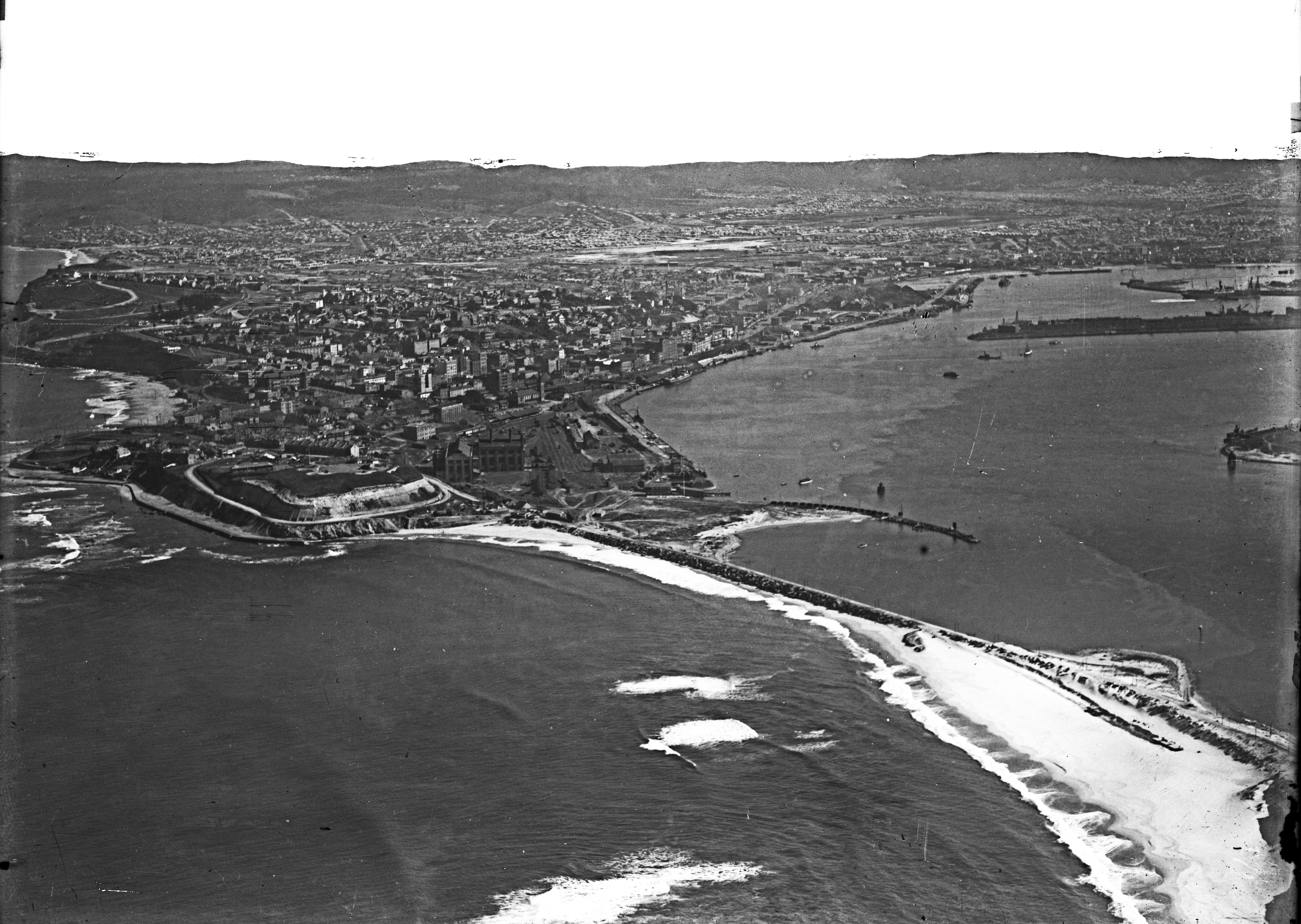
Merewether, Newcastle, Signal Hill, Fort Scratchley, Zaara Street Power House, Port Hunter, Wave Trap, Stoney Point, The Dyke, The Basin, Bullock Island (Photograph by Milton Kent Airplane Photographs, Sydney. Southern No. 66.-.-.-.1935.W.jpg)
“Newcastle From The Air” 22 August 1928, p.17 Sydney Mail. (Located by Jude Conway in TROVE)
Newcastle Entrance, Knobbys head, Signal Hill, Fort Scratchley, Merewether, Port Hunter, Wave Trap, Pirate Point, Stockton, The Dyke. (Photograph by Milton Kent Airplane Photographs, Sydney. Southern No. 61.6.-.1.1934.jpg)
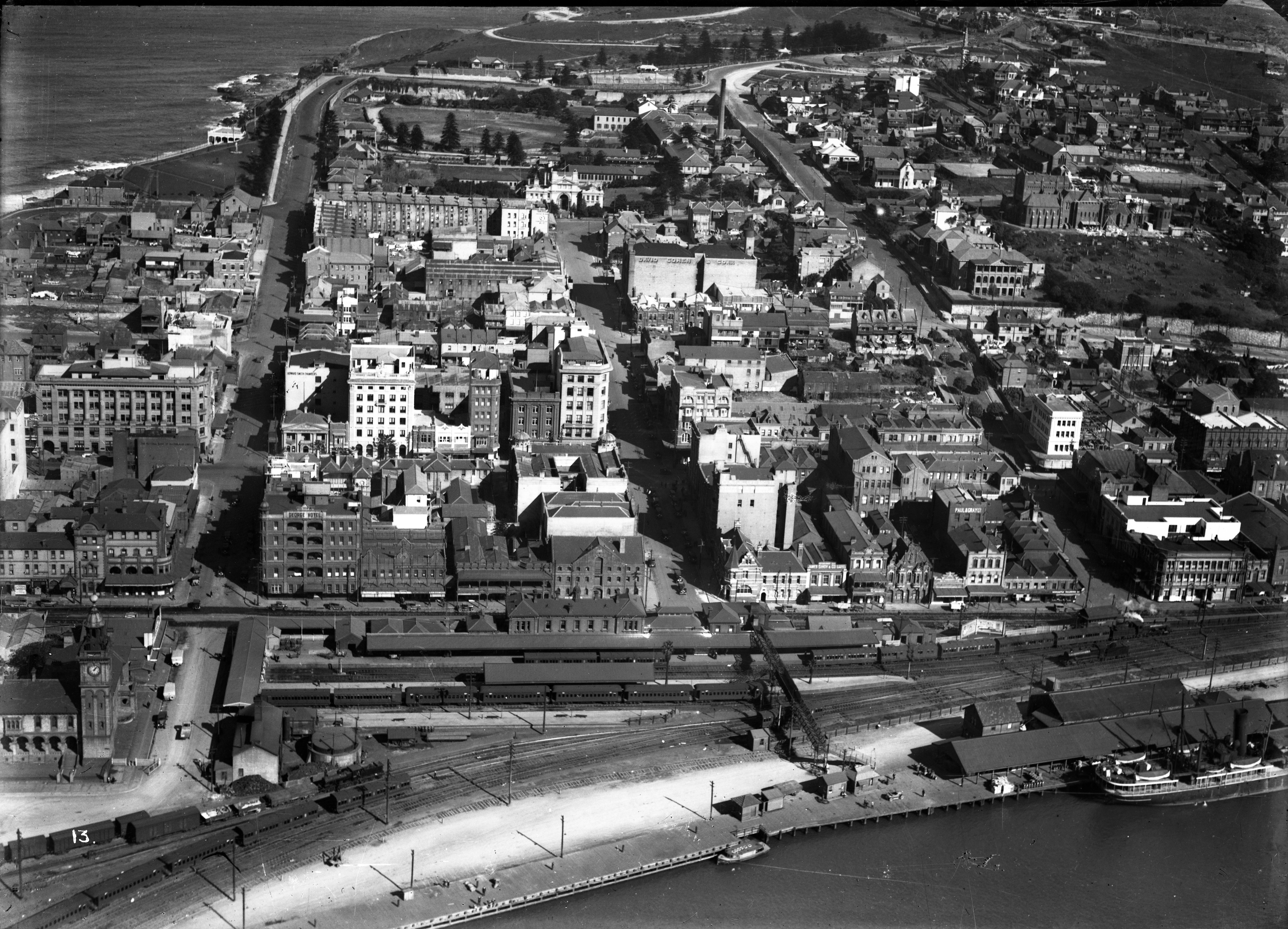
Newcastle, King Edward Park, Watt Street, Bolton and Newcomen Streets, Church of England Cathedral, Customs House, NSWR Station, 19, 35 and 32 class locomotives. (Photograph by Milton Kent Airplane Photographs, Sydney. Southern No. 67.-.-.13.1935.S.jpg)
Newcastle aerial, rail, circa 1928. Newcastle, Stevenson Street, Scott St., Hunter St., King St., NSW Railway Station, 19, 35 and 32 class locomotives. (Photograph by Milton Kent Airplane Photographs, Sydney. Image labelled 68/13 now 68-1935 Courtesy of Phillip Warren)
Newcastle, Stevenson Street, Scott St., Hunter St., King St., NSW Railway Station, 19, 35 and 32 class locomotives. (Photograph by Milton Kent Airplane Photographs, Sydney. Southern No. 68.-.-.14.1935.E.jpg)
Port Hunter, Stockton, Knobbys Head, Newcastle, The Dyke, The Basin, Carrington, Bullock Island, Cowper Street Bridge Over Throsby Creek, Hannell Street. (Photograph by Milton Kent Airplane Photographs, Sydney. Southern No. 56.5.-.2.1930.SM.jpg)
Newcastle, Port Hunter, Stockton, Walsh Island, The Dyke, Carrington, The Basin, Bullock Island, Throsby Creek. (Photograph by Milton Kent Airplane Photographs, Sydney. Southern No. 57.3.-.7.1930.S.jpg)
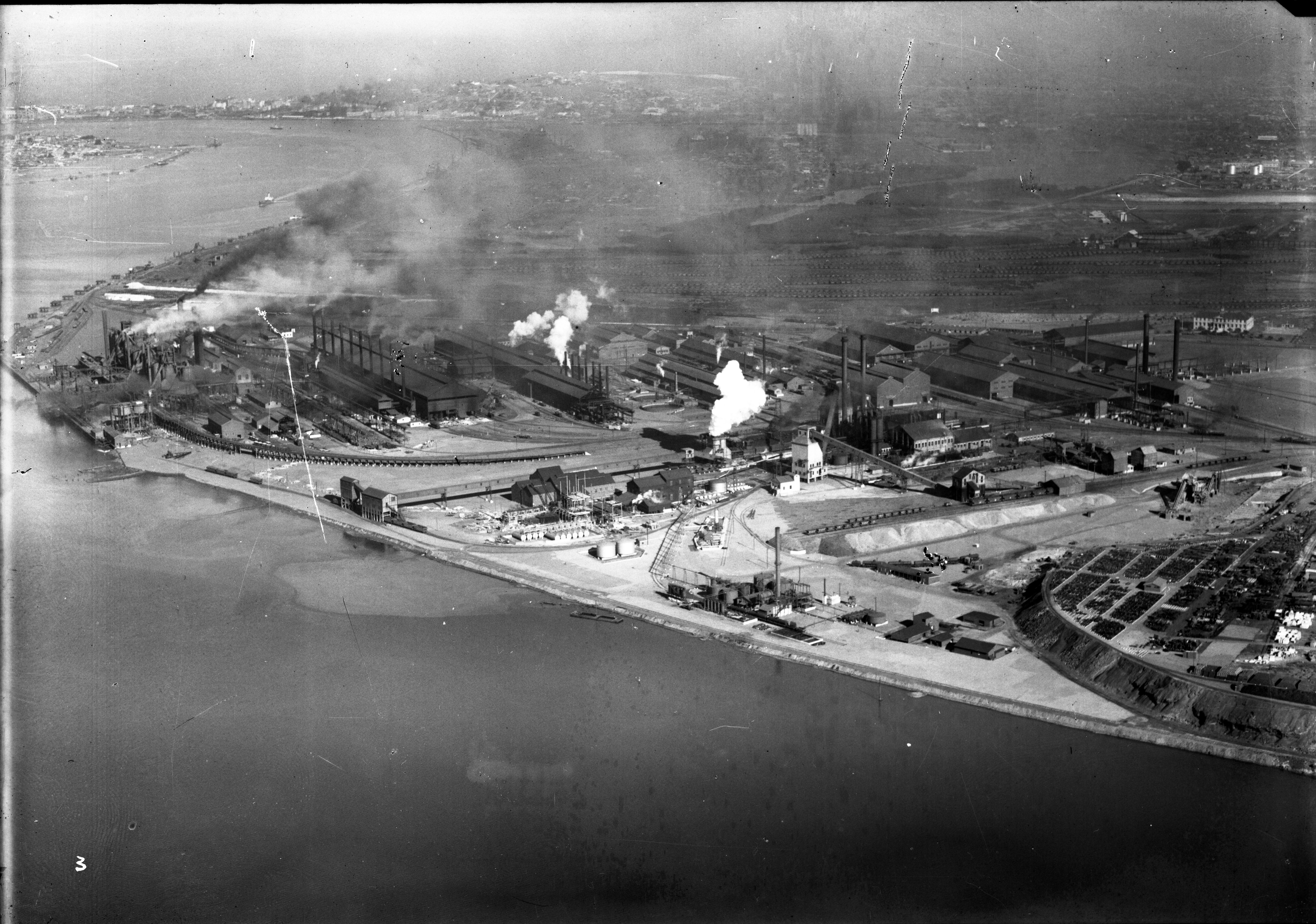
Port Hunter, Stockton, Walsh Island, Port Waratah, Carrington, Bullock Island, The Dyke, Ingall Street, Lysaght Works, Rylands, BHP, 9 Open Hearth stacks, Merchant Mills, Brink Plant, Administrative Building, Crebert Street, Bull Street, Arthur, William, Avon, Vine and Kerr Streets, Mayfield. (Photograph by Milton Kent Airplane Photographs, Sydney. Southern No. 58.-.-.8.1930.jpg)
Port Hunter, Stockton, Moscheto Island, Walsh Island, Port waratah, South Channel, Lysaght Works, Rylands, BHP, Ingall Street, Bull, Arthur, William and Crebert Streets Mayfield. (Photograph by Milton Kent Airplane Photographs, Sydney. Southern No. 59.-.-.11.1930.jpg)
BHP, three blast furnances, Raw Materials Trestle, 10 Open Hearth stacks, 7 Soaking Pit stacks, Coppee-Wilputte Coke Ovens, Coke Screen House and Bins, By-Products Plant. (Photograph by Milton Kent Airplane Photographs, Sydney. Southern No. 62.4.-.1.1935.jpg)
Port Hunter, Stockton, Walsh Island, Port Waratah, BHP, Coke Screen House and Bins, By-Product Plant, Wilputte Coke Ovens, Pig Mills, New By-Product Plant, Spares Area and Slag Dump. (Photograph by Milton Kent Airplane Photographs, Sydney. Southern No. 63.3.-.2.1935.jpg)
Newcastle, Port Hunter, BHP, three Blast Furnances, Raw Materials Trestle, 10 Open hearth stacks, 7 Soaking Pit stacks, Coke Screen House and Bins, By-Product Plant, Coppee-Wilputte Coke Ovens, Pig Mills, New By-Product Plant, Spares Area and Slag Dump. (Photograph by Milton Kent Airplane Photographs, Sydney. Southern No. 64.9.-.1935.S.jpg)
BHP, Merchant Mills,Brick Plant, Administrative Building, Tirrikiba, Rylands, Lysaght Works, Ingall Street, South Channel.(Photograph by Milton Kent Airplane Photographs, Sydney. Southern No. 65.5.-.-.1935.SE.jpg)
Port Hunter, Newcastle, The Dyke, The Basin, Carrington, Cowper Street bridge over Throsby Creek, Bullock Island, Hannell and Michael Streets. (Photograph by Milton Kent Airplane Photographs, Sydney. Southern No. 69.-.-.19.1935.S.jpg)
Georgetown, NSW Rail Broadmeadow, Show Ground, Australia Road and Stormwater Drain, Thorn Road, Broadmeadow Road, Hartley Vale branch railway, Goninan & Co. Workshop, Lambton Coal Company Railway, Caledonian Collieries Ltd railway. (Photograph by Milton Kent Airplane Photographs, Sydney. Southern No. 71.3.-.-.1935.SE.jpg)
Lake Macquarie Entrnace, Swansea Heads, Reid’s Mistake, Signal Staion, Northcote Avenue, Caves Beach. (Photograph by Milton Kent Airplane Photographs, Sydney. Southern No. 72.6.-.-.1935.jpg)
Terry Gravolin July 18, 2014 at 6:20 am
Damn it! Everything you do is so darn interesting. I wish I had more hours in my life to appreciate all your great work. Keep it up and I will keep cheering you on. Regards, Terry Gravolin
Reply
russell rigby July 21, 2014 at 10:38 am
I think the tags have to be extended or revised to say “Newcastle 1920s” – the Town Hall clock tower (completed 1929) is not evident in any of the photos that cover that part of Newcastle.
Image 68 (dated1935) shows construction work on the nave of Christchurch – Barry Maitland in “Architecture Newcastle – a guide” refers to
the four arches of the crossing and the nave walls raised and roofed (1928).
Images of Nobbys Beach dated 1935 do not show the pavilion (opened 1934) and Shortland Esplanade around the foot of Fort Scratchley is incomplete. In addition there is no sign of the depression-era “Camp Shortland” at Horseshoe Beach.
Reply
Jeff Mullier July 22, 2014 at 12:52 am
Image 71 is of the then new Broadmeadow works of A. Goninan & Co. The railway lines to Waratah Colliery at Charlestown (the gully line0 & the line to (old) Lambton Colliery are in the foreground with the Waratah line being the closest (the site of the junction of the railway line to the original Waratah tunnel Collieries is also visible.
Reply
Graeme Steinbeck July 28, 2014 at 2:45 am
The photos, Image 68/13 and Image 68/14, show two buildings being constructed.
One building is the Dalgety Shipping Offices on the corner of Watt and King streets.
If you look you will see, Image 68/13, a “crane” on top of the building and also the lack of a facade.
Image 68/14 shows the building with a facade but work is still being done. Apparently the building was completed in 1927.
Also you can see in 68/13 the other building being erected on the corner of Scott and Hunter streets. This was until recently, last decade or so, a Commonwealth Bank branch. Again the two images show progress in connection with the construction of the building.
The Australian and NewZealand Bank on the corner of Brown and Hunter streets appears to be very new in appearance and the lack of a footpath, in Image 68/13, may demonstrate that the building is not yet open to the public.
According to an advertisement an optometrist relocated his business to this new building March 1927. Image 68/14 shows a new footpath in front of the bank which may indicate the building is open for business.
There is another building in the process of demolition shown in Image 68/13.
Image 68/14 shows construction on the same site being carried out.
I will let you find this site!
Just to narrow down any broader opinions as to the date of Images 68/13 and 14, the AMP Building was completed in 1925 and is visible. The Newcastle Herald Building was completed 1929/30 and is not visible in either photos.
Just for the record all of this information came from a tourist map not an academic education.
It would appear that the two images could be dated to between late 1926 and prior to March 1927. The photos could have been taken to show the growth in construction in the area as they appear to be before and after images. Just a theory.
Reply
Graeme Steinbeck July 28, 2014 at 5:56 am
The contracts for the new Dalgety and Co. Offices were signed 22 December 1926.
This would rule out 1926 as a possible year of the images creation.
The offices were opened 15 October 1927.
I would put money on the images being created between March and September 1927.
It may be possible to narrow the dates further.
Reply
Pingback: Milton Kent’s Airplane Photographs of Newcastle | Coal River Working Party
Coal River “working” party have resubmitted (August) the subject (aerial photos) while providing a link to their earlier earlier request (July) for assistance in dating the same photos now again provided.
Copy, paste…. Comes to mind.
What of “cut”???
Clearly the replies were CUT from the transfer, “copy and paste”, (July to August) which included the above input from non-“party members”.
Is it any surprise that the public appear to be missing from this web site?
It’s a funny thing that I was once told by an academic. He told his students that he found more readable history in tourist information than he did in academic papers.
No matter what your name is or whatever qualifications you have there is only one title that you need to be aware of in the public opinion of achievement.
Two years later and still the only person commenting.
The book “City of Newcastle, Souvenir. Civic Week. 1929” places a question mark on the copyright of the above photos.
There are copies of the above photos, within the book, that are copyrighted by John Reid Ltd, Newcastle.
The Souvenir book was printed by Davies & Cannington Ltd., and Reg. C. Pogonoski.Ltd., in conjunction.
The 1927 telephone directory lists the following:
“Reid, John (M’dise), Ltd., Watt st ..
Connected with – Mr . W. Smith, Mr. K. Robbins, Sole Selling Agnts, Rothbury Collieries; Shpng,
Customs, and Ins. Agnts; Local Agnts, Phoenix, Union Marine and National Mutual.”
It would be interesting to know who owns the photos.
Milton Kent was probably contracted to take the photos for John Reid?


Newcastle from the air, circa 1928
Posted on July 18, 2014 by uoncc
Same photographs same stupid request for information in regards to dating the photographs.
Wait a second…..
Terry Gravolin July 18, 2014 at 6:20 am
Damn it! Everything you do is so darn interesting. I wish I had more hours in my life to appreciate all your great work. Keep it up and I will keep cheering you on. Regards, Terry Gravolin
Reply
russell rigby July 21, 2014 at 10:38 am
I think the tags have to be extended or revised to say “Newcastle 1920s” – the Town Hall clock tower (completed 1929) is not evident in any of the photos that cover that part of Newcastle.
Image 68 (dated1935) shows construction work on the nave of Christchurch – Barry Maitland in “Architecture Newcastle – a guide” refers to
the four arches of the crossing and the nave walls raised and roofed (1928).
Images of Nobbys Beach dated 1935 do not show the pavilion (opened 1934) and Shortland Esplanade around the foot of Fort Scratchley is incomplete. In addition there is no sign of the depression-era “Camp Shortland” at Horseshoe Beach.
Reply
Jeff Mullier July 22, 2014 at 12:52 am
Image 71 is of the then new Broadmeadow works of A. Goninan & Co. The railway lines to Waratah Colliery at Charlestown (the gully line0 & the line to (old) Lambton Colliery are in the foreground with the Waratah line being the closest (the site of the junction of the railway line to the original Waratah tunnel Collieries is also visible.
Reply
Graeme Steinbeck July 28, 2014 at 2:45 am
The photos, Image 68/13 and Image 68/14, show two buildings being constructed.
One building is the Dalgety Shipping Offices on the corner of Watt and King streets.
If you look you will see, Image 68/13, a “crane” on top of the building and also the lack of a facade.
Image 68/14 shows the building with a facade but work is still being done. Apparently the building was completed in 1927.
Also you can see in 68/13 the other building being erected on the corner of Scott and Hunter streets. This was until recently, last decade or so, a Commonwealth Bank branch. Again the two images show progress in connection with the construction of the building.
The Australian and NewZealand Bank on the corner of Brown and Hunter streets appears to be very new in appearance and the lack of a footpath, in Image 68/13, may demonstrate that the building is not yet open to the public.
According to an advertisement an optometrist relocated his business to this new building March 1927. Image 68/14 shows a new footpath in front of the bank which may indicate the building is open for business.
There is another building in the process of demolition shown in Image 68/13.
Image 68/14 shows construction on the same site being carried out.
I will let you find this site!
Just to narrow down any broader opinions as to the date of Images 68/13 and 14, the AMP Building was completed in 1925 and is visible. The Newcastle Herald Building was completed 1929/30 and is not visible in either photos.
Just for the record all of this information came from a tourist map not an academic education.
It would appear that the two images could be dated to between late 1926 and prior to March 1927. The photos could have been taken to show the growth in construction in the area as they appear to be before and after images. Just a theory.
Reply
Graeme Steinbeck July 28, 2014 at 5:56 am
The contracts for the new Dalgety and Co. Offices were signed 22 December 1926.
This would rule out 1926 as a possible year of the images creation.
The offices were opened 15 October 1927.
I would put money on the images being created between March and September 1927.
It may be possible to narrow the dates further.
Reply
Pingback: Milton Kent’s Airplane Photographs of Newcastle | Coal River Working Party
Cut, copy, paste are wonderful research tools?
Coal River “working” party have resubmitted (August) the subject (aerial photos) while providing a link to their earlier earlier request (July) for assistance in dating the same photos now again provided.
Copy, paste…. Comes to mind.
What of “cut”???
Clearly the replies were CUT from the transfer, “copy and paste”, (July to August) which included the above input from non-“party members”.
Is it any surprise that the public appear to be missing from this web site?
It’s a funny thing that I was once told by an academic. He told his students that he found more readable history in tourist information than he did in academic papers.
No matter what your name is or whatever qualifications you have there is only one title that you need to be aware of in the public opinion of achievement.
RICHARD CRANIUM
Two years later and still the only person commenting.
The book “City of Newcastle, Souvenir. Civic Week. 1929” places a question mark on the copyright of the above photos.
There are copies of the above photos, within the book, that are copyrighted by John Reid Ltd, Newcastle.
The Souvenir book was printed by Davies & Cannington Ltd., and Reg. C. Pogonoski.Ltd., in conjunction.
The 1927 telephone directory lists the following:
“Reid, John (M’dise), Ltd., Watt st ..
Connected with – Mr . W. Smith, Mr. K. Robbins, Sole Selling Agnts, Rothbury Collieries; Shpng,
Customs, and Ins. Agnts; Local Agnts, Phoenix, Union Marine and National Mutual.”
It would be interesting to know who owns the photos.
Milton Kent was probably contracted to take the photos for John Reid?
Just a thought.