
Toll, or Rose Cottage is a mysterious little cottage nestled inside the modern footprint of the Family Law Court in Bolton Street Newcastle.
Its quaint size and simple shape immediately calls to mind the convict era cottage structures that you find have survived all over Battery Point in Hobart. Could this little place be Newcastle’s oldest building, and along with Macquarie Pier 1818 (a.k.a. Newcastle Breakwater), an early surviving relic from Newcastle’s convict past?
We have assembled as much historic data as we can currently that relates to either the type of building structure, or the actual structure(s) that appeared in the vicinity of the current location in Bolton Street. If anyone has any further information and imagery please let us know by adding your views in the comments. The overlays of the mapping have been created in Google Earth. Remember, click on all the images to see the high resolution versions for greater detail and examination.
For a history of Toll Cottage (formerly Rose Cottage) see the NSW Office of Environment and Heritage (OEH) entry here: http://www.environment.nsw.gov.au/heritageapp/ViewHeritageItemDetails.aspx?ID=2170147
1804
Ferdinand Bauer – Settlement at Newcastle is an 1860s copy on linen of an original painting by Bauer showing the landscape of the site of Newcastle as it appeared in 1804, and shows an example of the built structures at the time. The original is lost, but photographs appear to exist of the original. See our former blog post on the matter here: https://hunterlivinghistories.com/2010/02/18/ferdinand-bauer-1804-view-of-newcastle/

1807
T. R. Brown Newcastle in 1807 (Courtesy of the Newcastle Art Gallery) is a painting that depicts the extant cottage and building structures on the landscape at that time. As a reference from now on, please note is the little wharf that begins to appear in the paintings, lies at the end of what is now our Watt Street. From at least 1818, recorded on the Meehan Plan for the construction of Macquarie Pier, it was known as “George Street”. So, to find our little cottage we need to look to the next street to the west for our current location of Bolton Street. Again, at the time from at least 1818, the next street to the west of George (later Watt) Street was known as “St Patrick Street”.

Newcastle, 1807
Watercolour on paper.
Photograph: Bruce Turnbull. Courtesy Newcastle Region Art Gallery.
1812
T. R. Browne Newcastle, in New South Wales, with a distant view of Point Stephen, 1812 is an engraving (No.6) which forms part of a panorama with its companion (No.5). Again, click on the images below to see the higher resolution views of the “cookie cutter” building structures just like our Toll Cottage on the early colonial landscape of Newcastle. Again note the number of such structures on what was to become “St Patrick Street”.


View of Hunters River, near Newcastle, New South Wales, 1812. Copper Engraving. Nos 5 & 6.
Photographer: Bruce Turnbull. Courtesy Newcastle Region Art Gallery.
1812
T. R. Brown. Settlement of Newcastle. 1812. Taken from the base of Prospect Hill. T. R. Brown, Pinx Plate 2. (Courtesy of the State Library of NSW). Another view, from a drawing that may have been the study used to create the engraving above. Again note the style of the cottage structures, and those inhabiting what was to become St Patrick Street.

1818
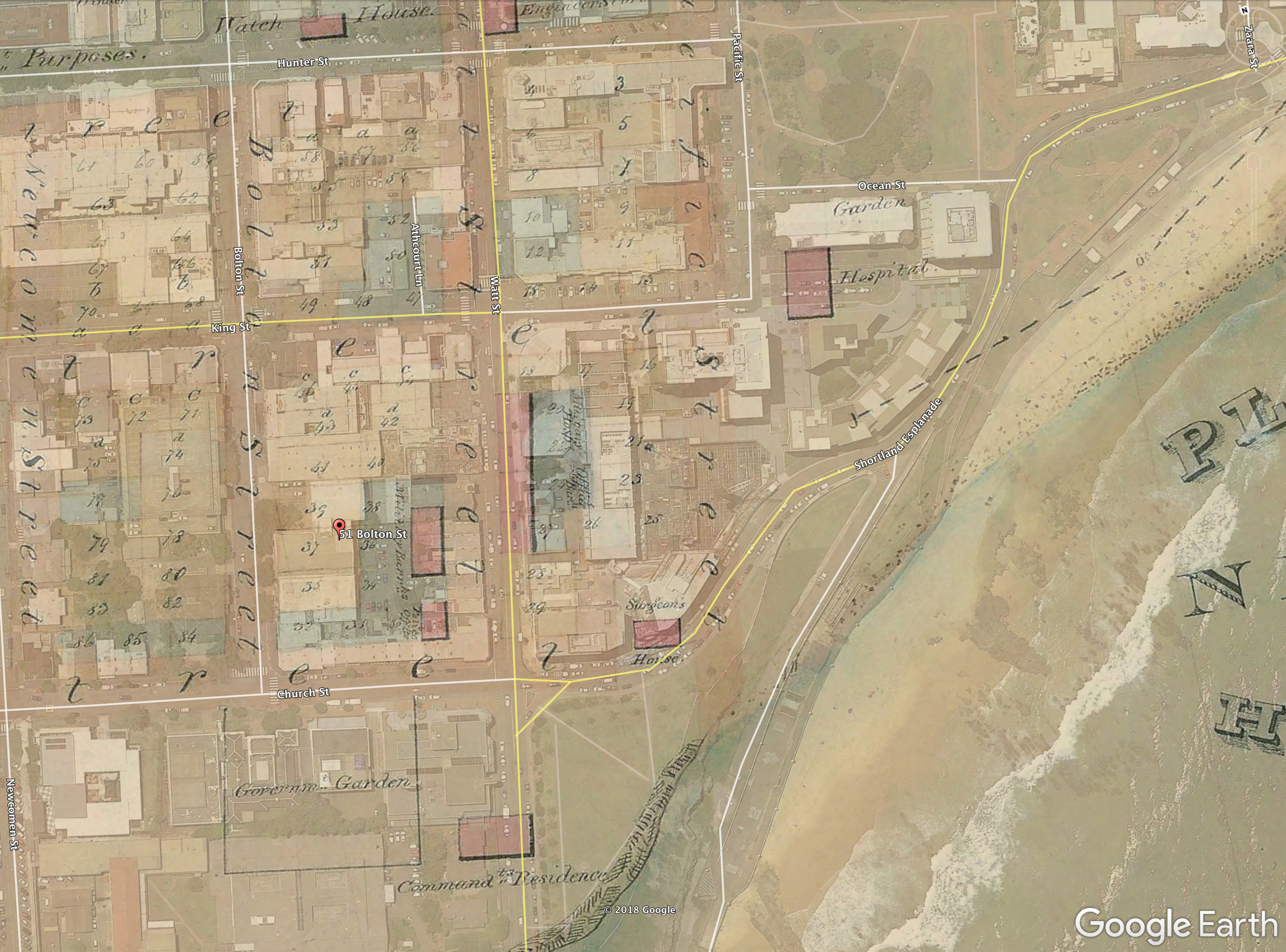
James Meehan Esq. Plan of Newcastle New South Wales August 7th 1818 By James Meehan Esq. Dep. S. Gen. (AO Map 83 Courtesy of State Archives and Records NSW) shows the original streetscape of Newcastle in 1818. Note that our current Watt Street was George Street, and the street immediately to the west was St Patrick Street. The overlay of the vicinity of 51 Bolton Street is below to clarify. No structures are shown on the site according to this plan.


1822

[1823?]
Henry Dangar. Plan of the Town of Newcastle on Hunters River. circa 1823? AO Map No. 4398 (Courtesy of State Archives and Records NSW) shows the site of 51 Bolton Street as occupying allotment 37. Allotment 37 is listed as belonging to “A. Beveridge” on Dangar’s “Names of Persons who have orders for Town Allotments”. No structures are shown existing on that site.

c.1821 – c.1825
Edward Charles Close. Panoramas of Newcastle


The Panorama (reconstruction from the original paintings by the University of Newcastle) above is constituted of the following paintings in Sketchbook of scenes of Sydney, Broken Bay, Newcastle and region, New South Wales, 1817-1840, (Courtesy of the National Library of Australia) once attributed to Sophia Campbell, now Edward Charles Close, 1790-1866 (Thanks to Mark Metrikas for identifying this find) The individual paintings that make up this Panorama from the Sketchbook are listed in order from left to right: (1) Commandant’s house from in front of the old gaol, Newcastle, New South Wales, ca. 1828 [picture] (2) Dwellings, fenced land and the windmill on the hill, Newcastle, New South Wales, ca. 1820 [picture] (3) Barracks with Christ Church in the distance, Newcastle, New South Wales, ca. 1820 [picture] (4) Dwellings and buildings in Newcastle, New South Wales, ca. 1820 (5) View over buildings towards the signal mast and Nobby Head, Newcastle, New South Wales, ca. 1820.
1828
Sir Thomas Livingstone Mitchell (1792-1855). Sketch of Newcastle in 1828 from Field Book – Port Jackson and Newcastle, 1828 (C 40)(Courtesy of the State Library of New South Wales). A detailed comparison of extant structures in Bolton Street in 1828. Is our cottage in the view?

1829
The document above forms a suite of papers located at the State Archives and Records NSW Authority in Sydney relating to Newcastle’s public infrastructure in 1829. It is important as it lists details of all public buildings including a number of cottages in Bolton Street. See especially those numbered from 18 to 23 as possible contenders for our original Toll Cottage.

1830
John Armstrong. See https://hunterlivinghistories.com/2013/02/07/newcastle-in-1830/
Direct Link: https://hunterlivinghistories.com/wp-content/uploads/2013/02/1830-armstrongplan-newscan3.jpg
John Armstrong’s 1830 plan is generally regarded as a very accurate record of what was on the the Newcastle landscape at that time, and should be compared in context with Rodd’s 1829 Return as well as Sir Thomas Mitchell’s 1828 sketches. At the location of 51 Bolton street appears a structure labeled as “Govt cottage out of repair”.


Charles Martin states:
I created an overlay of the Armstrong Plan with Google Map (as at April 2018). My opinion is that the present “Toll Cottage” is not the one depicted in the Close and Mitchell renditions. The cottage building (identified as “3” in blue on the central image) above is rectilinear, with a hip roof with the ridge running north south (as are just about all the small cottages depicted). Toll cottage is near enough to square with a gable roof and a ridge line running east west. It also has a loft floor which doesn’t appear to feature in any of the cottages in this area depicted in the early paintings. Since this cottage, and other Government buildings, were noted as being in “poor repair” (see 1828 Rodd Return, and on the Armstrong 1830 map), it could be assumed that shortly after this time the building was either reconfigured, or torn down and built anew from salvaged materials. The act of building, and then demolishing, seemed to be a common practice where repair was deemed nonviable. Some buildings may have become the victim of the encroaching sand drifts close to the beach after some of the vegetation in that area had been removed, as they don’t appear to be found in Sir Thomas Mitchell’s 1828 sketches, whose survey work, incidentally, I trust to by 100% accurate. Perhaps the “Toll Cottage” was a new-build for the Commissariat’s Clerks after the need for repair to existing (and other new outbuildings required) made it more viable to begin afresh?

1844
The Town of Newcastle and its Harbour (in 1844) shows the site of 51 Bolton Street as occupying the area between two allotments 47 and 49.


A pencil version of a plan from the same era, [Town of Newcastle, New South Wales] see: https://trove.nla.gov.au/work/16818033 reinstates the location as between allotments 37 and 39, as it appeared in the Dangar 1823 plan. So could the cartographer of the 1844 plan The Town of Newcastle and its Harbour (in 1844) (see: https://trove.nla.gov.au/version/19739356) have made a mistake with the numbers? It also states the possible owner of the land as “Kemp” (Simon Kemp?).


1845
An 1845 map of Newcastle, held in the Local Studies section of Newcastle Region Public library identifies the allotment 37 as being now owned by an “A. Beveridge” and allotment 39 as “D. Maguire”.


1849
John Rae, 1813-1900. Newcastle in 1849. (Courtesy State Library of New South Wales). For information on John Rae, and the methods used in creating the panorama (using the camera lucida) below see Dr Ann Hardy’s work located here: https://hunterlivinghistories.com/2011/09/13/john-rae-and-newcastle/

Charles Martin states: The 1849 panorama above was drawn from the veranda of Claremont House, and it is from there that a sight line to present day Toll Cottage can be established. Its location should be just behind the Wesleyan Hall. It is interesting to note that that the other two cottages (to the south) that were there in the 1830 Armstrong plan appear to have been removed, as well, it would seem all other similar simple dwellings of the early 1800’s, being replaced by larger and more substantial structures. Could it be that what is there today in 51 Bolton Street was built at around the same time as the other buildings that appear in the later c.1880 photographic panorama taken by Rae?


Charles Martin continues: I have tried to locate exactly where Rae may have positioned himself to attempt the panorama. Since it is reasonable to assume that the Wesleyan Hall was on lot 49, then, by using the ridgeline, once could conclude that Rae was sited on the very southern end of the Veranda. By drawing sight-lines from here to the existing Toll Cottage, it would appear that it (if indeed it did exist by then) it would wholly be obscured by the Hall. Thus, I think we can’t be assisted by Rae’s fine painting as to the existence or otherwise of Toll Cottage on this site in 1849. The Google Map’s property boundaries are pretty correct, but some of the present day building footprints are a bit out in places. However Claremont House is pretty correct, and the Wesleyan Hall would have occupied the site where a free standing terrace house now stands. I surmise that Toll Cottage may have been built sometime in the 1860-80 period, and not be the continuing structure from the 1820s as previously assumed.
Another question is whether the Wesleyan Hall (in Rae’s 1849 panorama) and the Lyceum Hall (see 1890 photo below and 1889 image from the Illustrated Sydney News) were the same building, and if that may have altered Martin’s conclusions as to where Rae may have been located for his panorama on the Claremont House first floor veranda (north or south?), and whether he may have been able to view the Rose Cottage site?
Martin has come to the conclusion that they were not the same building, although having a very similar elevational appearance. The Wesleyan hall is smaller (in width and height) than the Lyceum Hall, which is simpler in its detailing, is set back from the street boundary, and is clearly close to the southern boundary of the Wesleyan Church’s two adjoining lots. The Lyceum Hall is located further north. See image below.

Therefore, we can conclude that the previously illustrated sight-lines are in the main correct, and the site of Rose Cottage would have been wholly obscured by the Wesleyan Hall (school?) in Rae’s 1849 panorama.
1860
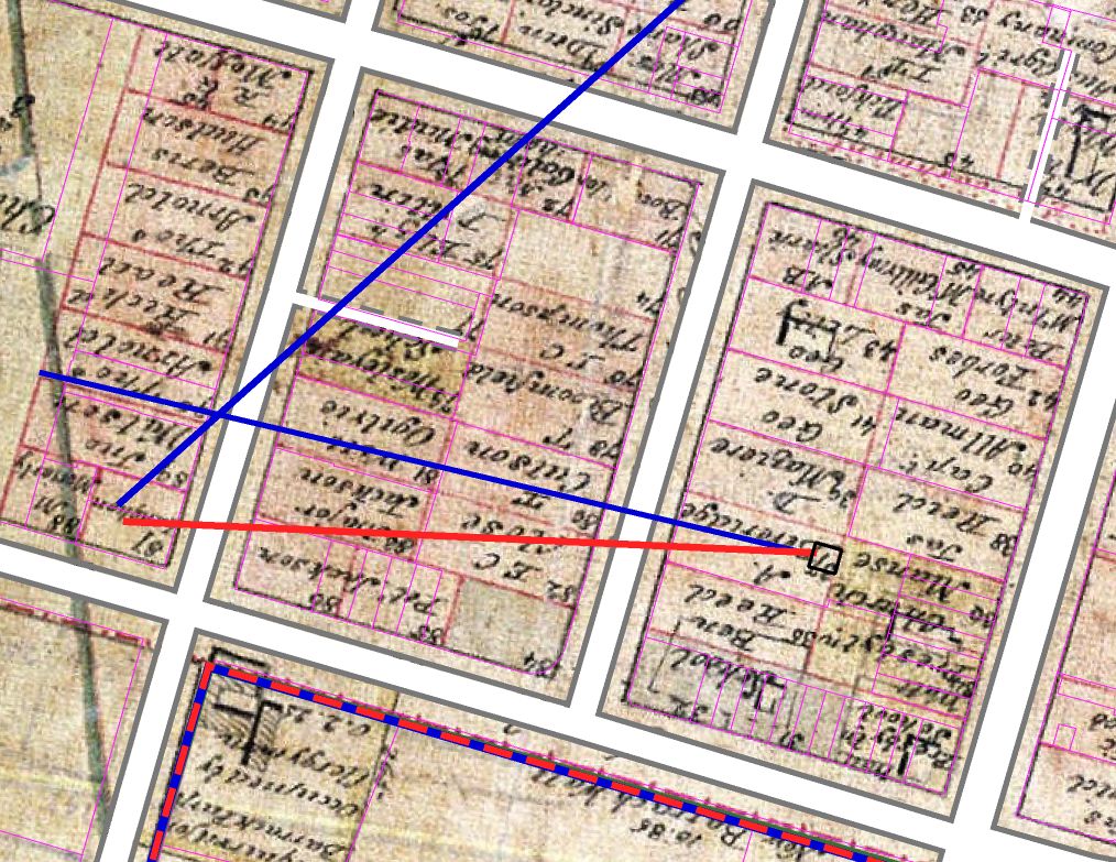
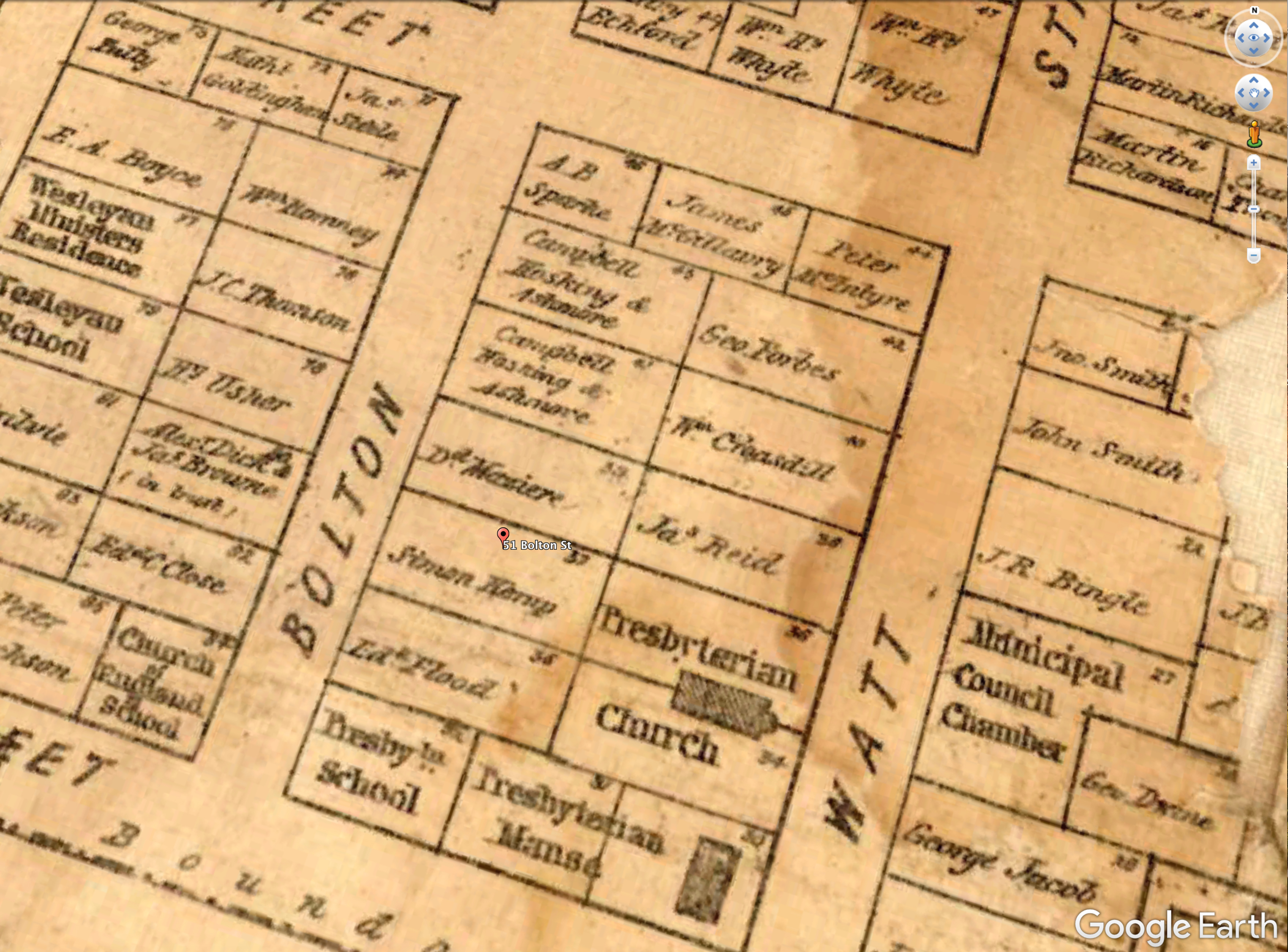
M4721 Map of the City of Newcastle, County of Northumberland, NSW, July, 1860. (The Bingle map) showing the site of present day 51 Bolton Street as occupying allotment 37 owned by Simon Kemp.


1870s
From Russell Rigby (13 April 2018):
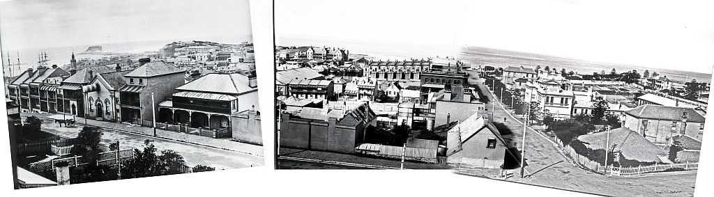
A few years ago I compiled a couple of incomplete panoramas of Newcastle East, using photos from the early 1870s and 1897 in Cultural Collections and State Archives. Some of the images took a bit of juggling because the size and quality weren’t consistent. I have attached annotated copies of the panoramas with particular reference to the site of Rose Cottage which unfortunately is obscured by the Limerick Hotel building in both images (roof line may be visible). The links to my Flickr collection also contain references to the images in Cultural Collections.
I have also attached a series of high resolution copies of the some of the basemap overlays from 1818 to 2017, showing the approximate sight lines to the Rose Cottage site. Unfortunately I haven’t yet found a map from 1870s showing building details, just lot boundaries.
jgw files are text world files so that the map images can be loaded into a GIS system if required. I can also generate .kmz files for Google Earth – let me know if you would like copies.


Newcastle East panoramas: https://flic.kr/p/dBJtKm
Panorama from near NW corner of Newcomen St and Church Sts early 18 70s taken from area on eastern side of Christ Church, above back yards of houses in Newcomen St. Date range using date of gaol demolition and hospital construction Flagpole on extreme right of image may be identifiable in other contemporary images. Building used for Limerick Hotel prominent. Photos courtesy of UON Cultural Collections.
1875
It was originally published in the Illustrated Sydney News of April 1875 and contains a key identifying the buildings and important features of the landscape.


1880s
John Rae, 1813-1900. [Panoramic photograph of Newcastle, 1878-1882, possibly taken from Jesmond House]

Rae, John, 1813-1900. [Panoramic photograph of Newcastle, 1878-1882, possibly taken from Jesmond House] — 4 albumen photoprints
from Sketches in New South Wales in the olden time 1842 – 1859 by John Rae, M.A. / album of watercolour panoramas and photographs of watercolour sketches. (Courtesy State Library of New South Wales.)

David Campbell replies to Charles Martin stating: I think you are right about the Rae photo showing the cottage opposite the old Denominational School (building with bellcote above gable) on the site of the former Newcastle East Public School/Court House annexe/flats. I think I may just be able to make out the roof of the cottage above the little dwelling next to the terrace where Grand Hotel now stands. Funnily enough, that little dwelling is referred to in Braggett’s From Convict Era to Modern Times about Newcastle East Public School. I have looked at one of the Cultural Collection’s overlay maps of Bolton (should be Boulton) Street overlaying the Armstrong map (late 1820s I think) across what is there now; I think Toll’s may be built on the footprint of an older building shown in the Armstrong map; this may have been a rather frail dwelling, whether brick or just brick nogged behind weatherboards, but with pit-fired bricks that would have been very friable due to low/uneven firing temperatures, so despite lime-washing would not have had longevity unless protected by all-round verandah. If you visit the site http://www.environment.nsw.gov.au/heritageapp/ViewHeritageItemDetails.aspx?ID=2170147 you will see interiors and exteriors. The upstairs window, squat chimney makes one think that the place could date from early 1830s, as after the arrival of the Australian Agricultural Company in about 1830 opened their well-capitalised A Pit colliery it brought new prosperity (and therefore potential for brick buildings such as Toll’s) to a town that had been descending into dilapidation after the relocation of the convict station to Port Macquarie, with just the convict public works gang/small scale commercial activity/ a few convalescents attracted by the seaside providing the main economic activity. It was after the relocation of the convict station in 1826 or whenever it was that the rather frail buildings of that period were generally abandoned; the few that had some longevity were the stockade/convict hospital at the lumberyard; the hospital on the later site of the Royal Newcastle hospital; and the gaol at what is now Parnell Place.
1883
A reference to the unoccupied land in the vicinity, owned by Mr. Finney in Bolton Street is to be found in an 1883 report of Council proceedings, This refers to unoccupied land near the Limerick Hotel, and needs closer study:
COUNCIL. (1883, November 14). Newcastle Morning Herald and Miners’ Advocate (NSW : 1876 – 1954), p. 3. Retrieved April 10, 2018, from http://nla.gov.au/nla.news-article135954377
REPORTS. From the INSPECTOR OF NUISANCES, reporting on Mr. Finney’s letter, dated 29th ult., that he visited Mr. Finney’s unoccupied land in Bolton-street, near the Limerick.Hotel. He saw a pool of stagnant drainage water lying there, which had been .carried thither by a brick culvert crossing under the lane from premises above, and terminating at the southern boundary of the allotment. The culvert discharged the whole of the drainage into the land. Mr. Finney asked the Council to abate a nuisance which existed upon his own premises, and over which he had full control. He should either proceed against the parties offending, or at once stop the nuisance running on to his ground. The only way for the Council to interfere was by proceeding against Mr. Finney for having unclean premises. If the nuisance was not at once suppressed, the place alluded to by Mr. Finney, as having been drained in accordance with the City Engineer’s plan was the allotment upon which Mr. Finney lived, and had no communication with the nuisance above referred to.
Alderman KEIGHTLEY moved – “That a copy of the report be sent to Mr. Finney, and that he be requested to see to the matter.” He (Aldermen Keightley) was sure Mr. Finney had no desire to offend his neighbours or to break the by-laws.
Alderman CREER said the engineer might prepare a plan to take away the whole of the drainage; to which the property-owners might agree to subscribe. Alderman CnAr.!iAN said some of the .property-owners had once refused to sub-scribe to the work. Mr. Finney had filled iin his land and blocked it up, and if all the neighbours would agree to do this there would be no difficulty in draining the place. He thought it would be as well if the property-owners in the vicinity were asked to confer with the Drainage Committee, and he moved a motion to this effect. Alderman KEIGHTLEY withdrew his motion and concurred.
Alderman MOORE seconded, and said Mr. Finney was rather to be pitied than blamed. He had done his best in the matter. The motion was carried.,
1886
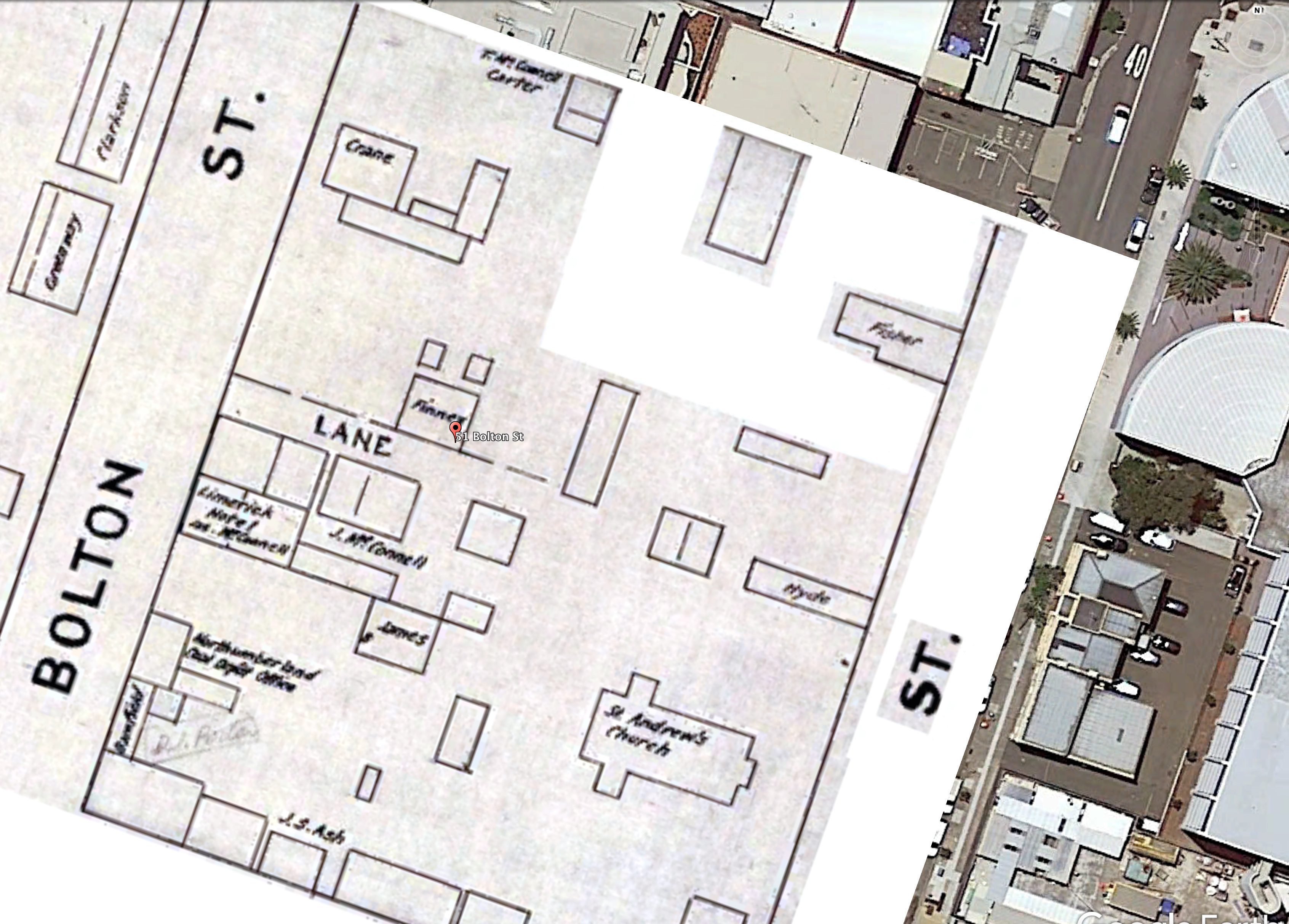
Mahlestedt & Gee Plans of the Newcastle landscape show the site of 51 Bolton Street near or on the site of land owned by “Finney”. Mr Russell Rigby has identified a legend to the plans below from another set of Mahlstedt and Gee Standard Plans of Melbourne. Assuming the legend they used for the 1888 Melbourne maps are their standard, we can conclude that similar colours and symbols apply to those Newcastle maps below:
pink: brick or stone
yellow: wood building
blue: iron faced building
hatched: roof only


Russell Rigby, has also located some information about the former owner of Rose Cottage.
Joseph Finney (c1830-1913) There are references to Joseph Finney in the Newcastle Morning Herald in the 1870s working as a carrier with 2 or 3 carts around Newcastle. During the 1880s are more mentions in articles, council reports and advertisements about houses for rent and land for sale in Bolton Street, Church Street Bull Street and Wickham. He stood unsuccessfully for Council in 1888, and in the nomination he was described as a property owner of Bolton Street. He and his wife Elizabeth moved from 65 Bolton St to High Street between 1895 and 1900. He died in 1913 aged 83 at High Street, and his wife died the following year.
The Rose Cottage site and surrounds in 1886, are mentioned in a report on Trove of the Licencing Court proceedings regarding the Limerick Hotel. The Limerick Hotel was on Bolton Street, on the southern side of of the lane leading into Rose Cottage. The Mahlstedt & Gee plan shows that Rose Cottage and another building were owned by Joseph Finney, who gave evidence at the Licencing hearing, against the renewal of the licence.
- APA citation
- LICENSING COURT. (1886, June 26). Newcastle Morning Herald and Miners’ Advocate (NSW : 1876 – 1954), p. 7. Retrieved April 10, 2018, from http://nla.gov.au/nla.news-article138809118
… Joseph Finney stated that he was a resident of Bolton-street, about 30 yards distant from the hotel. The hotel had been a source of annoyance to him on account of the number of bad women who frequented the hotel. Had seen fights on several occasions between men coming out of the hotel. Had complained to the police about the disturbances. …
1887
- APA citation
- Advertising (1887, March 5). Newcastle Morning Herald and Miners’ Advocate (NSW : 1876 – 1954), p. 2. Retrieved April 10, 2018, from http://nla.gov.au/nla.news-article138817939
TO BUILDERS.
TENDERS are invited for the Erection and Completion of TWO BRICK RESIDENCES in Bolton-street, Newcastle, for Joseph Finney, Esq. Plans and specifications to be seen at my office, where tenders are to be delivered not later than SATURDAY, 12th MARCH, 1887. The lowest or any tender not necessarily accepted. JAMES HENDERSON, Architect. Office: Bank Chambers, Bolton-st. 1265
Obviously there were problems because 5 months later:
Advertising (1887, August 10). Newcastle Morning Herald and Miners’ Advocate (NSW : 1876 – 1954), p. 1. Retrieved April 10, 2018, from http://nla.gov.au/nla.news-article132504174
Newcastle, August 6, 1887.
Notice.
TO JAMES H Le PETIT, BUILDER, &c.,
I AM instructed by Mr. Joseph Finney to draw your attention to the fact, that unless you proceed with the erection and completion of his FOUR HOUSES in Bolton street, Newcastle, in accordance with your Contract, within the NEXT SEVEN DAYS from date, he will enter upon and take possession of the works, and employ others to complete the same at your risk and expense, using any materials delivered on or near the premises for the said works.
JAMES HENDERSON, .
Architect.There are numerous advertisements in the Newcastle Morning Herald and Miners’ Advocate for Finney’s properties for sale or rent – some of these will be for Rose Cottage, but more study will be needed to see if it can be identified.
1889
Newcastle, N.S.W. from the Illustrated Sydney News, 27 June 1889. See the blog post here for further information and high resolution detail from this printed artwork: https://hunterlivinghistories.com/2017/04/07/newcastle-1889/


1896
Water Board plans


1897
From Russell Rigby (13 April 2018):
Panorama from near NW corner of Newcomen St and Church Sts. Left photo appears to be from same verandah, maybe slightly north of centre and right photos strong shadows on centre and right photos, left photo has very diffuse shadows, so overcast but probably afternoon similar to other photos – can’t be sure of time on Customs House clock, but may be 3:50. I have used the sight line over the northern edge of the Lyceum Hall to the Customs House tower, as well as the property boundaries in Newcomen St to locate the left image. There is a possibility that the left image was cropped from a wider image when printed, so the gap in the panorama may be reduced if a different version of the image can be found. This panorama is extremely useful because it puts buildings on the detailed footprints surveyed in the 1890s Waterboard plans, and shows the developments in Bolton St around the Rose Cottage site.


1950’s to the 1970’s
According to Dr Ann Hardy, Toll Investments Pty Ltd purchased the dwelling in the 1950s, restoring it during the 1970s and 1980s, and gifted it back to the city.


2017

Gionni Di Gravio
April 2018
I listed it for the NT in the early 1980s or late 70s. It was then believed to be Newcastle âs oldest, between 1828 and 1832.
We didn’t know then about the surviving c 1819 fabric at (now demolished) Kirkwood, Church St. So the answer is yes.
Just to clarify.
The answer is “NO” plain and simple, based on research not opinion.
The Maitland Mercury, 31 October 1878, page 6, (see: http://nla.gov.au/nla.news-article18828082) provides:
“in 1857 Finney’s house was begun, …”
“… Finney had his drays there from 1857 or 1858 up to present time;”
The same article provides, from witnesses interviewed at the time, that the land was vacant prior to Finney building his house.
The vacant land Finney bought was part of the many lots offered for sale in the Church, Bolton and King streets area during 1857.
The two terrace houses (left side of laneway almost opposite of Finney’s house) that Finney had problems with (Newcastle Herald 05 March 1887 http://nla.gov.au/nla.news-article138817939) are shown on the Mahlstedt & Gee (1886) map.
The other four terrace houses (Newcastle Herald 10 August 1887 http://nla.gov.au/nla.news-article132504174) are not shown on the plan but are visible in photographs as being located to the north west (left side of laneway entrance) of Finney’s cottage and two houses facing Bolton street.
I cannot explain why the Mahlstedt & Gee map does not show the buildings but they are shown in photos as being constructed on Finney’s Land.
There is no reference to the building being referred to as the “Rose Cottage” but a Newcastle Sun article, 26 Jan 1923, page 6 provides the following:
“Boolaroo Winners … Below is the first section of sporty sports ideas of the winners of the three principal races at Boolaroo to-morrow. … J. Rose, 54 off Bolton-street, Newcastle.” See: http://nla.gov.au/nla.news-article163194411
Something to consider.
Thanks for providing those references.
The c1819 fabric was nothing more than the remains of the old parsonage/deanery.
The building was demolished around 1902, according to the archeological report.
As the “Kirkwood” reception building, recently demolished, was built using some recycled sections of the older parsonage the sum of the parts of the old parsonage building would not sensibly support the “new” Kirkwood building as a whole to qualify as being convict built.
From what I have seen in the archeologically report it is no surprise that the Office of Environment and Heritage did not consider the site/building worth preserving.
Interesting. I thought it looked too sturdy and salubrious to date back to the penal station. Has Charles been able to identify ownership/occupancy of any of the cottages built prior to 1822? I have the odd reference to ownership or exchange of huts but nothing to identify locations.
Try this site Tamsin, but check it against the new overlays we have done, as there are questions about the allotments. http://www.environment.nsw.gov.au/heritageapp/ViewHeritageItemDetails.aspx?ID=2170147
Thank you I will. It would be so great if we could identify where particular hut’s were – like Mrs Young’s Disorderly House or the ‘best Huts and gardens’ Wallis allocated to his most skilled tradesmen. Or the house Purcell thought they should buy for married soldiers and so on. I am interested in the spatial arrangements of the settlement to see how the Young’s and the many convict smugglers managed to avoid direct surveillance. It would give real life to the recent VR project too if we could place people and their activities on the street map.
How interesting. I thought it looked a bit sturdy to be from the Penal Station years. Has Charles been able to identify occupancy /ownership of specific huts prior to I822? I have the odd reference to ownership and exchange (which surprise me) but nothing that rates to specific locations. Nor even anything that gives a clear picture of government v private ownership.
Sorry I fell asleep looking at all the pointless information so I cannot give an “qualified” opinion until I fully wake up.
So is the building “old” or what?
If it is the oldest then it’s twin would also be worth a mention!!
There is a second building of the same design within a kilometre.
The building does not appear in a c1865 photo of the area.
Another photo taken c1877 does show the building.
Pretty much narrows the construction date if the evidence stands.
10 minutes of work based on nothing more than a walk around Newcastle, two buildings of the same design and two old photos.
Lucky I decided to spend my Univeristy fees on research rather than academic achievement.
Hope the above helps with your research.
An 1875 photo of the area shows the building to the left of a church in Watt street.
The building is identified as the “cottage” by the above provided information.
The building design can be confirmed as the same as its twin as a missing window (present day) is visible, on the “cottage”, that the twin still retains today.
Clearly the “Toll” restoration was not accurate in regards to the roof layout.
So I can assume that the time period for construction is now narrowed to within a ten year period between 1865 and 1875 based on photographic evidence.
Strewth you lot at “Coal River” waste a lot of time with pointless facts.
They come in handy for helping me sleep though.
Hope the information is helpful.
Graeme I am astonished you summoned the energy to respond – twice and at such length.
How much energy do you need.
Woke up again.
The posted information provides the Mahlstedt & Gee 1886 map showing the only two brick buildings owned by Joseph Finney in Bolton street.
Also supplied is the 1887 newspaper advert for the construction of two brick buildings for Joseph Finney.
See where the evidence is going Mr Parsons????
No, the building is not convict built.
Finney requested two building be built and two buildings are shown on the map.
Yes the dates (map 1886, advert 1887) are chronologically wrong but using “only” the information supplied this is the only solution that makes sense.
Outside of the research material posted the Toll building is visible in a 1875 photo and I stand by my earlier comments and agree with Charles Martin that the building was constructed outside of the convict period of occupation.
The convict buildings had their front and rear doors facing east and west.
The Toll building doors face north and south.
The convict buildings are shown in pictures as laid out uniformly in “military order” along the convict streets.
The Toll building is outside of the “ranks/lines” of the convict layout.
The building simply does not fit into the interpretation of convict Newcastle and therefore could not be part of Newcastle’s penal history,
The repeated statement by Tamsin that “I thought it looked to sturdy … to date back to the penal station” must have taken a great deal of time and effort to reach this conclusion.
For Keith to say nothing more than ” yes it is convict” is without validation.
Can Tamsin and Keith back up their comments?????
Nice to know Charles had a go even if he put me to sleep with the repetiveness of his presentation.
I’m not sure what I’m supposed to be backing up – I simply remarked that in my opinion the structure looked too sturdy to date back to the penal station. The convict huts were thrown up in their own time with very basic materials and were starting to crumble soon after the station closed. I had no evidence about the cottage under discussion either way – just an opinion. An opinion that would in any case appear to be in agreement with the conclusion that it is not convict built. I simply don’t understand why your tone is so antagonistic.
To quote your opinion:
“Graeme I am astonished you summoned the energy to respond – twice and such length.”
Clearly the opinion is not for the resolution of the question of the subject provided for discussion.
Why not try a question. They sometimes provide answers.
My tone is due to three decades of involvement with local history.
Considering that I have been diagnosed with depression and anxiety (2000) you could be astonished that I have summoned the strength to contribute to the discussion with the full knowledge that nothing will come of the subject. This is my experience not opinion.
The hunter living histories site is a dead site as nothing ever becomes of the information presented or more importantly the input from the reader.
A subject is presented, possibly discussed and then nothing.
There are no amendments or further refinement of the material gathered such as that currently presented in regards to the Toll Cottage.
It is not public friendly and it has worn me down trying to understand why the current subject has to be so complicated in its presentation. My 18 year old daughter agrees as she fell asleep also.
I cannot expect you, the reader, to understand that it takes me hours to produce any comment due to anxiety and allegedly autism.
You may take minutes to provide a comment but I cannot do the same.
For a site that has such a resource of material through Newcastle University this site simply does not exist in the eyes of the public or provide quick and simple access to information.
Charles Martin has used technics that I have been using for over ten years in regards to establishing the location of the camera and the sight lines to interprete the information provided.
Some of the photos that were joined to recreate the panoramic vistas I had already created, dated and identified the individual sites of prominent structures.
It does not take to much effort to date photos if you know the history of Fort Scratchley for example.
If you wish to understand why I have depression please consider Shepherds Hill, as an example, which has been in the media over the last year or two.
I was invited to meet with the head consultant to assist with the conservation management plan (CMP) for the Shepherds Hill site.
When I presented my research in regards to the site, collected over three decades, the consultant stated that the information was “to detailed to include in the CMP and I was then asked to check the CMP for errors but make no corrections.
The CMP cost just over $60.000 or about $198.00 per page and when it was presented to the Department of Environment and Heritage for endorsement (a fee of around $2000 applied) the Department refused to endorse the CMP as it contained no history and therefore could not demonstrate the historical significance of the site.
The CMP has been resubmitted (another potential $2000 fee) and nothing has been heard since December last year.
The listed time for processing a CMP should be about a month for processing and approval or refusal.
Shepherds Hill is just one example of what I have been involved with so please consider that for all my grumping I still continue to, or attempted to, contribute to the preservation of our local history despite my personal views that I am wasting my time.
In 2007 I asked the principal of Hamilton Public school what was happening in regards to the schools 150th in 2008?
He said nothing was going to happen as he claimed that the school was not entering its 150th year in 2008 despite the fact that the school uniforms, stationary and signage all clearly stated the school had been established in 1858.
The schools parents and teachers group agreed with the principal that 2008 was not the 150th year.
The school had its 150th celebrations as my wife and I did not take no for an answer.
It was a short battle but the students were allowed to learn about and celebrate their heritage in the 2008.
Life should not require long stories about small problems but people complicate things.
Hence frustration and depression.
I am not sure if this quote is relevant but it might have some bearing:
Sung San Suu kyi
Burmese political leader
On returning to Burma.
“It’s very different from living in academia in Oxford.
We called someone vicious in the Times Literary Supplement.
We did’nt know what vicious was.”
Very mature deleting posts that go against anything that opposes tha academic view.
Keith Parsons seems to some up this mentality with “yes it is convict in origin” with no further comment or proof.
I guess the fact that two cottages exist rather than one is frightening to some who want all the glory.
The building was constructed in 1857.
Check the newspaper articles.
I see that the Office of Environment and Heritage have listed the building as the “third oldest” in Newcastle.
https://www.environment.nsw.gov.au/heritageapp/ViewHeritageItemDetails.aspx?ID=5050461
I have correspondence in my family archives saying that the parents of my great great great grandmother Hannah Makepeace (née Fryar) lived in Toll Cottage (then known as Rose Cottage). The Fryar family (Thomas and Mary Ann with children) arrived in 1853 on the Star of the East.
Hi Jane, thank you for your comment about the Fryar family who lived at Rose Cottage, how fascinating, do you know if Fryar was in the Military ? In earlier decade the cottage housed families of married soldiers. To get an understanding of later families who live there is of great interest. Regards Ann
Hi Ann no military links that I’m aware of. They are part of my paternal grandmother’s line. We have drapers and missionaries way back and later insurance managers and doctors. I’m presuming they came to Newcastle for a new life. Hannah was already married so it was a whole of family migration.
Thomas Fryar lived 1796-1855.
I suspect they came for the coal mining. Hannah’s husband Thomas Tindale Makepeace is listed as a coal hewer and was involved in the early days of coal mining at Moggill, Queensland. He lost his leg in a mining accident and took up farming with his son, Thomas, establishing Makepeace Farm on Moggill Road. The farm sold in 1921 and the next owners built a Queenslander house which is listed as a local heritage place at 3600 Moggill Road.
Have found a record saying Thomas Fryar was a mine manager, explaining why he was such a relatively advanced age and brought the entire family. I guess coal was having a boom time?