
DOWNLOAD – Wollong Combined Converted V4 KT Master File Metric Only [DOWNLOAD 1.2MB XLSX FILE)
The “Wollong” (New South Wales) data set
The scientific transcription of the Wollong (New South Wales) data set has been completed. The spreadsheet is available for download above, and the metadata description is available below. These are the first of the historic Hunter Valley Weather Records that came to light in 2016 and were donated to the University of Newcastle’s Cultural Collections for further research by the Belfield Climate Research Team.
Where is “Wollong”?
The data set is clearly identified as being taken at “Wollong”. Wollong was the home of Charles Wyndham, 9th son of George and Margaret of Dalwood,and his wife Emily, neé Glennie. The weather records were signed by M. Wyndham, presumably Marion, eldest daughter of Charles and Emily. They date from June 1891 till end of 1907. (Ref: Dalwood House Newsletter No 93 by Don Seton Wilkinson).
A/Prof Howard A. Bridgman
Conjoint Professor
Editor, Air Quality and Climate Change
President, Clean Air Society of Australia and New Zealand
School of Environmental and Life Sciences
University of Newcastle
[SEPTEMBER 2020 UPDATE]
The Local Studies Librarian (and qualified Archivist) at Cessnock City Library alerted us that Local Studies hold the original weather records for the “Wollong” Station, encompassing the period directly after ours and are written in the same hand-writing, i.e. that of Marion Wyndham.
They hold:
- ‘Wollong’ Weather Ledger January 1908 – March 1918.
- ‘Wollong’ Weather Ledger April 1918 – December 1927.
- Annual rainfall observation sheets 1891 – 1951
These are part of their original record series on the ‘Wollong’ property, which is of great interest to them as it was in their Local Government Area. The ‘Wollong’ collection also includes the personal diaries of Marion Wyndham (1872-1928) and Mona Arline Wyndham (1893-1963), written while living at ‘Wollong’, journals, personal correspondence between members of the extended family and to outside business partners, financial records, farm diaries and two leather bound journals with additional weather observations for the period 1891-1927.
For a very long time now, the Eversleigh Team could not understand why the Wollong records ceased in 1907. Marion Wyndham recorded the best daily weather remarks description of all of our data sets. We had hoped to somehow find the rest of the records because we knew she lived until 1929.
So this information is a wonderful surprise for us. Once COVID safe, we hope to access the weather books, scan them and then, using our scientific volunteer network, digitise them into spreadsheets. We will then possess a record length of 35 years, second only to Eversleigh (45 years) outside of Armidale.
Metadata Information for Wollong (near Mt Vincent), New South Wales.
By Associate Professor Howard A. Bridgman.
Location and Ownership: In the Hunter Valley, 8 km west of Mt Vincent. Property (vineyard?) formerly owned by the Wyndham family, is now a sub-division accessed from Wollong Rd.
The weather observer was M. (Marion) Wyndham. Measurements taken at 0900 except as noted (very rarely).
Latitude and Longitude: 34.52 S; 149.33 E (Galmara on Wollong Rd)
Elevation: 43 m
Years of Weather Records: June 1891 to December 1907
Column Headers in Spreadsheet: Year; Month; Day of Month; Date; Pressure (inches, not translated to hpa); Dry Bulb Temperature (oC); Max Temp (oC), Min Temp (oC); Rain (mm); Wind Direction; Wind Force; Cloud Cover (10ths), Notes (including Monthly Rain and Remarks).
Overall Description of Weather Records: Note: All data have been transformed to metric except pressure.
- From June 1, 1891 to Dec 31, 1907: Max Temperature oC; Min Temperature oC; Rain (inches, 0 recorded if no rain ); Wind Direction (descriptive, i.e. SE, 8 compass directions); Wind Force (Beaufort Scale); Cloud Cover (10ths); Notes – general weather remarks. (Note: Structure and type of measurements suggest advice from the NSW Astronomer)
- All data for 1892 are missing
- Dec 12 to Dec 26, 1893, all data are missing
- All data for Jan 1 to April 29, 1894 are missing
- Starting July 4, 1898, missing Rainfall seems to shown by blanks instead of zeros; sometimes a zero is entered
- Very scattered Dry Bulb Temperature entries begin in Jan, 1899; notation is 0900
- Nov 28, 1899, Dry Bulb Temperature readings begin every day
- Dry bulb temp missing July 5-17, 1902
- Occasional Rainfall cells highlighted blue beginning in 1902 are a xlx problem, no meaning regarding the data
- Scattered written Pressure comments begin on Feb 14, 1903 (falling, rising etc.)
- From March 19, 1904, many Rainfall, Wind Speed and Cloud Cover cells are highlighted blue. This is an xlx problem, no meaning regarding the data
- June 28, 1904, blue highlights for cells disappear
- Sept 1, 1904, blue highlighted cells begin again for Rainfall
- August 8, 1904, scattered number values for Pressure begin
- June 3 to Jun 13 1905, Dry Bulb Temperature readings missing
- Sept 5, 1905, pressure readings recorded much more regularly each day
What overall information is missing?
- The actual location on the property where measurements were taken,
- The physical conditions surrounding “a”, especially any interferences
- The meteorological instruments used
- Whether the instruments were housed in some sort of protective box
- Where the rainfall measurements were taken an whether the rain gauge was baffled
General Overall Comments
- Frequency of measurements varies, but improves after 1896.
- Non-metric columns are hidden (except pressure)
- Blank cells mean missing data (no measurement recorded) (except Rainfall after July 4, 1898)
- The weather description is the notes column is extensive and very interesting. Handwritten comments difficult to read are highlighted in red, or indicated by ???.
- The pressure data only exist for a little over one year.
- It is likely that contact with the NSW Astronomer in Sydney was made, and advice about weather measurements made. This is deduced from the type of readings made (in comparison with other locations), and the 0900 time of measurements.
- Measurements end abruptly after 1907. The Bureau of Meteorology began operation in 1908.

Location of “Wollong” Station
By (the late) Russell Rigby (October 2018)
The location of “Wollong” property has been identified, the location of the house being in the vicinity of Galmara on Wollong Road 34.52 S; 149.33 E.
See the attached Google Earth kmz files for the original “Bonnington” grant and the property outline. The area of the grant matches the area of the ” Wollong” property in the transcript below (1280 acres, 2 sq miles).
The Cessnock Local History documents on-line show that the manuscript was in the Wyndham/Glennie papers transferred to UON Library archives in 1977.
The “Wollong” property is now subdivided into a rural subdivision, serviced by Wollong Road off Sandy Creek Road at Quorrobylong (recent aerial photograph and property subdivision in attached image.) Confusingly the property was about 8km (5 miles ) west of Mt Vincent, on the watershed between Wallis Creek which flows into the Hunter at Maitland, and Quorrobolong Creek which flows into the eastern branch of Wollombi Brook and into the Hunter at Warkworth.
Cessnock City Library Catalogue
Wyndham Family 1 vertical file. Location Cessnock Library Collection. Local History Collection. Call Number LH Status/Descview resource online http://cessnock.spydus.com/Blis/Da/dlf?id=153
Transcript of part of manuscript “The Wyndhams of “Wollong”” (34.5MB PDF File)
On the death of Rev Glennie in 1870 the widow Mrs[?] Anne Glennie, commenced the building of Wollong near Mount Vincent. In or around 1870 the house was commenced, and by 1874[?] Mrs Glennie and Mr and Mrs Charles Wyndham took residence.
The original grant of land was one thousand two hundred and eighty acres originally granted to John Brown and then known as “Bonnington” situated in the parish of Mulbring County of Northumberland.

The 1965 aerial photo (click for a higher resolution) from UON Cultural Collections, covering most of Wollong property – rotated to north, and saved as Google Earth kmz. The obvious building group in the Wollong property no longer exists, and falls right on the line of the Wollong Road. There are other photos in the collection covering the areas too.
There is a lot of detail in the 1965 photograph – which may be relatable to the history of Wollong – there appear to be possible vineyard areas showing as faint roughly North South lineations in some of the fields.
The position of the old buildings shown on the 1965 aerial photo is:
at/long: 32°55’18.46″S 151°25’15.74″E
UTM/MGA zone 56: 352362 m E 6356277 m S
elevation 150m AHD
Sample Pages from the Observations
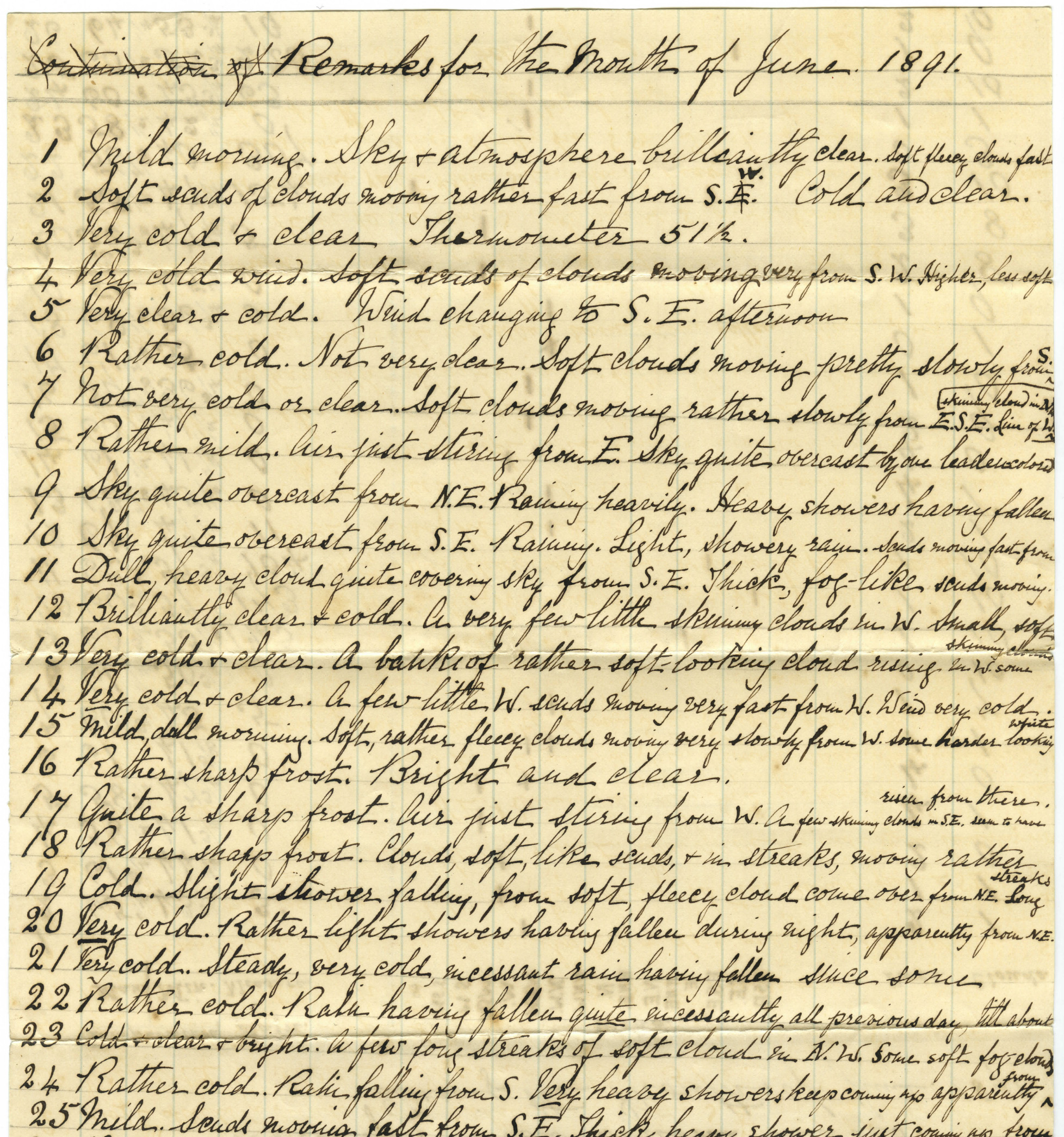


The Historical Data
The original observation records (from https://hunterlivinghistories.com/2018/01/10/hv-climate-data/):
- A5438(viii)-1891 Bundle of loose leaf papers. Meteorological Observations Made at Wollong New South Wales.
Observer: Marion Wyndham June 1891-December 1891.(72.9 MB PDF FILE)
- A5438(viiii)-1893 Meteorological Observations Made at “Wollong” Mt Vincent New South Wales.
Observer: Marion Wyndham. January 1893-December 1893 (August, October, December missing) (72.6 MB PDF FILE)
- A5438(x)-1894 Meteorological Observations Made at “Wollong” Mount Vincent New South Wales.
Observer: Marion Wyndham. May 1894 and Dec 1894. (37 MB PDF FILE) - A5438(x)-1894 Meteorological Observations Made at “Wollong” Mount Vincent New South Wales.
Observer: Marion Wyndham. January 1894 to Dec 1894. (57 MB PDF FILE)
- A5438(xi)-1895 Meteorological Observations Made at “Wollong” Mount Vincent New South Wales.
Observer: Marion Wyndham. January 1895 – December 1895 (113.8 MB PDF FILE).
- A5438 (xii)a-l Wollong Station. Meteorological Observing Book(s) For the Year(s) 1896-1907.
Observer: Marion Wyndham (Date Range: 1896 – 1907)- A5438 (xii)a Wollong Station. Meteorological Observing Book For the Year 1896 (114.8 MB PDF FILE)
- A5438 (xii)b Wollong Station. Meteorological Observing Book For the Year 1897(118.4 MB PDF FILE)
- A5438 (xii)c Wollong Station. Meteorological Observing Book For the Year 1898 (125.6 MB PDF FILE)
- A5438 (xii)d Wollong Station. Meteorological Observing Book For the Year 1899 (133.2 MB PDF FILE)
- A5438 (xii)e Wollong Station. Meteorological Observing Book For the Year 1900 (134.4 MB PDF FILE)
- A5438 (xii)f Wollong Station. Meteorological Observing Book For the Year 1901 (176.5 MB PDF FILE)
- A5438 (xii)g Wollong Station. Meteorological Observing Book For the Year 1902 (143.6 MB PDF FILE)
- A5438 (xii)h Wollong Station. Meteorological Observing Book For the Year 1903 (148.5 MB PDF FILE)
- A5438 (xii)i Wollong Station. Meteorological Observing Book For the Year 1904 (149.1 MB PDF FILE)
- A5438 (xii)j Wollong Station. Meteorological Observing Book For the Year 1905 (140.5 MB PDF FILE)
- A5438 (xii)k Wollong Station. Meteorological Observing Book For the Year 1906 (139.2 MB PDF FILE)
- A5438 (xii)l Wollong Station. Meteorological Observing Book For the Year 1907 (141.5 MB PDF FILE)
Further information on the Weather Records and Historic Climate Data Project is here:
https://hunterlivinghistories.com/category/weather-records-climatic-data/
Hi, these weather records are very similar to those the Hunter Valley Research Foundation donated to the University of Newcastle Archives around 2015.
Hi Brigid, They are the very same ones you donated! Now completely digitised, transcribed and available to climate researchers. There are two more data sets in the same batch yet to be completed. These are from are the latter period. See the original post here: https://hunterlivinghistories.com/2018/01/10/hv-climate-data/
Hi, very interesting. Just one point, the lat-long co-ordinates specified at the top of the article, is actually for a Galmara at 707 Wheeo Rd, Grabben Gullen NSW 2583. According to Google the correct co-ordinates are 32.92S, 151.42E. However, from a 1955 topographical map I have of the area, the co-ordinates are about 32.55S ,151.25E