MULLUNGBULA
Two Rock Women
(or the “Two Sisters”)

This work is conducted in memory and respectfully honours the First Australian People,
the Aboriginal People of this land.
Mullungbula is the name of a location on the northern extremity of the eastern side of Lake Macquarie where two upright conglomerate rocks could be found. The Reverend Lancelot Threlkeld was told that a certain black had beaten two women to death, for some trivial reason. They were instantly turned into two 9 foot high pillars. He reports that they were decomposing fast due to the salt air. Reid had made a wharf of stones at the site of these pillars, where he thought he had landed at Newcastle, and believed that it had been abandoned. The next vessel to the area discovered the mistake and called it “Reid’s Mistake”.
Lake Macquarie is known under two names, NIKKINBA (meaning place of coal) and AWABA (meaning place of smooth surface i.e., water). According to Clouten (1967, p.153) “Mullung-bula is now the site of the Swansea Heads pilot station, situated on an eminence on the southern side of the lake entrance.”
It appears they were perhaps destroyed from around 1884 in order to create the harbour works. They still appeared on maps as late as 1887. – (See Coode, Sir John, (1887) NSW Harbours. Lake Macquarie Entrance Plan, Shewing Works Recommended – Map. Ref: Swansea Heads Sustainable Living Guide)
However, there is conjecture about whether that location is correct. Please read the accounts below and let us know what you think from the evidence.
All ages artistic challenge. We don’t know what the two sisters Mullungbula actually looked like. No drawings or photographs of these two great stone women survive, nor is it known what became of them. Read the descriptions below, and see what your imagination can create. Bring Mullungbula back to life in art.
Descriptive Sources
1834
p.83:
“Mul-lung-bula, the name of two upright rocks about nine feet high, springing up from the side of a bluff head on the margin of the Lake. The blacks affirm, from tradition that they are two women who were transformed into rocks, in consequence of their being beaten to death by a black man. Beneath the mountain on which the two pillars stand, a seam of common coal is seen, many feet thick, from which Reid obtained a cargo of coals when he mistook the entrance of this Lake for Newcastle; a wharf the remains of his building, still exists at this place: from whom the name Reid’s mistake is derived.”
1836
From the Journal of G. W. Walker 29th April 1836 [Gunson p.127]:
“Accompanied by Lancelot E. Threlkeld and his son Lanceolet, we were rowed by three blacks to an old missionary station at the head of Lake Macquarie… Nothing now remained to mark the spot but the ruins of a chimney and some old woodword, and about 30 acres of cleared land [J.B.]
It is about 4 miles from “Ebenezer” to the old Grant, which is contiguous to the seashore; L.E. Threlkeld’s location being at the head of another branch of the Lake, and on the side furthest from the sea. The Lake is about 7 miles long, in its greatest extent from the sea; but in width it is probably, at least, 20 miles, in the widest parts. The object for which its shores were chosen, as the site of a Missionary Establishment for the aborigines, was this, that fish being a principal means of subsistence to the Blacks, and the borders of the Lake being constantly resorted to by them for that purpose, it was presumed a considerable number would always be accessible to the Missionary in such a situation. In this conjecture the originators have not been mistaken. The place remains to be one of resort, and the selection therefore judicious.
The first Establishment was erected on the edge of the Lake, little more than a mile in a direct line from the sea, from which it was separated by a considerable space of swampy, low ground, though the immediate site of the Establishment was on a gentle elevation. The buildings are all fallen down, merely the ruins remain. About 40 acres, that had been cleared, now present a fine herbage, though the soil is chiefly sand. Little more than a gunshot from the ruins of the Mission House, the termination of a rich vein of coal is to be seen on the shore; the vein is said to be 9 feet thick, and consists of two kinds, one of which is like “Kennel” Coal of England. The continuation of this stratum occurs on the opposite shore about 2 miles distant. We landed on this spot on our return; where there are two large upright rocks, bearing some resemblance to the human form, which are objects of superstitious tradition among the Aborigines, and are referred to in the Australian Grammar [A.L., 51]”
Please note: (Gunson is referencing Fraser’s 1892 edition of Threlkeld’s works, in which the Awabakal Grammar (1834) was reprinted, where the reference to Mullug-bula appears on p.51)
1841


1855
From the Christian Herald, 3rd February 1855, pp. 412-413 [Gunson p.64]:
“On the Northern extremity of the Eastern side of Lake Macquarie there is a bluff, at the foot of which are two upright rocks of the conglomerate kind, which the Aborigines have named, Mul-lung-bu-la; so called from Mullung, a proper name, and bula, the pronominal dual postfix, referring to a traditionary circumstance, that took place ‘a long time ago.’ To call in question the truthfulness of the tradition, would at once rank you amongst the “Stupid fellows,” as the Aborigines term all heterodox persons who have not implicit faith in, or do not hold the tradition of, their fathers. The tradition believed in by the Orthodox Blacks in regard to the two rocks is that a certain Black-man, from causes unknown to posterity, but supposed to be trivial, if any at all existed on the part of the dark sex, beat them most unmercifully to death! In consequence of such shameful treatment, they were instantly transformed into two upright rocky pillars about 9 feet high. On my carefully examining them I found that they were decomposing very fast, the action of the sea air causing the pudding stone to crumble, and the separated parts at the base of the pillars show the rapidity with which the process is being carried on. The Saline air has also a remarkable effect on the Sand-stone rock; for close to my former residence, at the Lake, there was a small cavern forming, owing to the particles of sand which composed the solid rock falling down from the side and roof, handfuls of Carbonate of Soda I gathered on the spot, and it appeared that this was combined with particles of sand, which composed the rock, and as it became affected by the sea air it effloresced. Nothing of the kind however exists in the two pudding stone black ladies. No imagination can create any likeness to the human form, eyes they have not, arms they have not, and as for legs, the blacks would tell you they have no need of any as the pillars were not intended to run away. Query, – has this tradition any reference to the transformation of Lot’s wife into a pillar of salt, and which tradition like all other traditions when merely committed to memory, from generation to generation, become fabulous, like the silly traditions of the “Roman Papacy?” (108) The Aborigines have also a tradition that a great flood covered all the neighbouring mountains, that but one family escaped in a canoe, and the blacks told me as a proof of the flood, that cockle and other shells were found on the mountain tops. You would be counted an unbeliever if you suggested that the shells being recent, must have been carried thither. Beneath the mountain, on which, at the base, the two pillars stand, there is a projecting seam of excellent coal of the caking description, and not like the seam in other parts of the Lake, which is technically called open burning coal, from not having the quality of caking so as to form a cinder but burning with a bright flame, throwing out great heat, and burning to a greyish ash, without clinker, and when “prejudice, which has neither eyes nor ears,” shall be sufficiently mesmerised to permit common sense to test many things, the Lake Macquarie coal, with its millions and millions of tons approachable on the surface level may be found of some use as an auxiliary to the Steam Navigation in these colonies. Having no landed interest at Lake Macquarie, this observation is made merely for general information. The blacks call Lake Macquarie Nik-kin-ba, (109) from Nikkin, Coal, and ba place of, meaning a place of coal. The lake upwards of twenty miles from North to South, and in some places eight miles from East to West abounds with both description of coal. It is improperly called a Lake, it is in reality a Lagoon having a shallow entrance from the sea, and which was mistaken, by a Captain Reid, for Newcastle, when that place, then called the coal river, was first discovered. It is self-evident that our rivers and harbours since that time have become much shallower, including Sydney harbour, which at the bar, near the Sow and Pigs, has become not so deep by several feet that it was when first laid down in the Maps. It was at the foot of the two figures the coal cropped out, and there Captain Reid made a wharf of stones, which remain, and on which I landed to see the pillars, and there he took in a cargo of coal, and sailed to Sydney, stating to the Governor that Newcastle was abandoned, that all the prisoners must have escaped, and what had become of the officials he could not say, but the most fearful suspicions were entertained as to their fate. The next vessel discovered the mistake, and from that day to this, the entrance to Lake Macquarie has been called “REID’S MISTAKE.” Three or four miles by water from this place there is another point called by the Aborigines Mun-nu-kan a proper name; Etymology unknown. Underneath this point there crops out a seam of canal coal, beneath which there is a seam of superior common coal, both jet into the sea in three or four fathoms of water. The then Government Surveyor, Mr. Busby, together with the late Mr. Henderson, of the Australian Agricultural Company, found on examination, that the two veins were nearly nine feet thick and the coal of an excellent quality.” – Christian Herald, 3
February 1855, 412-3. (Reprinted in Gunson, p.64)(108) This is one of the few places where Threlkeld hints at a connexion between the ancient world and the Aboriginals, and he never develops this. (Gunson, p.78)
(109) i.e. as distinct from their tribal name, Awaba, which also alluded to the lake, meaning smooth surface. (Gunson, p.78)
1887
Coode, Sir John. (1887) NSW Harbours. Lake Macquarie Entrance Plan, Shewing Works Recommended, 1887.
The “re-location” of the “Sisters” to the northern edge of the Swansea Headland foreshore occurs in the Sir John Coode map of 1887. The copy of the map was kindly provided through the Swansea Historical Society. This map by Coode is the only map ever to have recorded a location of the “Sisters”.
Sir John Coode was an English engineer who visited Australia and then returned to England and provided advice on portconstruction to the Australian colonies. In 1887 he was engaged by the government of NSW to provide advice on improvements to the channel at Lake Macquarie to give better access to the collieries in the Lake. He did this from his office in London. At this time there were several collieries operating at Green Point and Cardiff Points. The collieries were owned and operated by the Cardiff Coal Company. The owner of Cardiff Coal Company was George Alfred Lloyd who was the Member for Newcastle in the NSW Parliament at this time. Lloyd held many positions in the NSW Government including NSW Minister for Mines. Lloyd was also the son-in-law of Rev Threlkeld.

1892
“Mullug-bula, the name of two upright rocks about nine feet high, springing up from the side of a bluff head on the margin of the Lake. The blacks affirm, from tradition, that they are two women who were transformed into rocks, in consequence of their being beaten to death by a black man. Beneath the mountain on which the two pillars stand, a seam of common coal is seen, many feet thick, from which Reid obtained a cargo of coals when he mistook the entrance of this lake for Newcastle. A portion of a wharf built by him still exists at this place, which is still called Reid’s Mistake ; i.e., in 1834].” (Threlkeld, reprinted in Fraser, p.51)
1892
[Reprinted in Fraser (1892)]
Threlkeld, L.E. (Lancelot Edward), 1788-1859. [From the original manuscript] An Awabakal-English Lexicon to the Gospel According to Saint Luke by L.E. Threlkeld. Now for the first time printed. Sydney, Charles Potter, Government Printer, 1892. (p.225)
Mulug – close by; nigh at hand.
Mulug kakilliela – was and continued to be close by.
Mulug kakillilo – to be near.


1967
Clouten, Keith H. Reid’s Mistake: The story of Lake Macquarie from its discovery until 1890. Lake Macquarie Shire Council, 1967.
“According to Rev. L.E. Threlkeld, whose knowledge of the Awabakal lore and legend is authoritative, ‘Mullung-bula’ (1) was the name given by the aborigines to
…two upright rocks about nine feet high, springing up from the side of a bluff head on the margin of the Lake. The blacks affirm, from tradition, that they are two women who were transformed into rocks, in consequence of their being beaten to death by a black man. Beneath the mountain on which the two pillars stand, a seam of common coal is seen, many feet thick, from which Reid obtained a cargo of coals when he mistook the entrance of this lake for Newcastle. A portion of a wharf built by him still exists at this place, which is still called Reid’s Mistake
Mullung-bula is now the site of Swansa Heads pilot station, situated on an eminence on the southern side of the lake entrance. Reid’s Mistake is still the official name given to this headland, reminding us of the time when the entire lake was known by this title. Thus is perpetuated the name of the lake’s discoverer, and the unusual circumstances associated with the discovery.” – Clouten p.153
c.1986
[From the Percy Haslam Papers]
“MULLOONG-BOOLA (Together two) This is the name given to two upright rocks about nine feet in length at Swansea Heads (Yirita-ba, the sacred place) and near the site of a burial ground where an excavation of relics and bones proved, by the carbon dating process, an aboriginal presence of up to 8000 years ago. The Awabakal told Threlkeld that the two women were transformed into rocks after having been beaten to death by a native man.
Underneath this foreshore bluff was a seam of common coal several feet thick, and from which Captain Ried (of Reid’s Mistake fame) took cargoes to Sydney. He was the mariner who mistook Swansea Channel opening as the entrance of Newcastle Harbour. The site for many years became known as Reid’s Mistake; the name of Lake Macquarie followed years later. Reid built a coal wharf there, and for any years remnants of this structure could be seen.
Not far from this spot is what is known as the tessellated pavement. While it is agreed that this unusual formation, seen best at low tide, is the handiwork of nature, there is also a likelihood that some of the configuration was the work of man. This pavement is known at other shore sites from Swansea to Newcastle. A similar pattern of beach pavement has been found in an aboriginal site area in South Australia.”
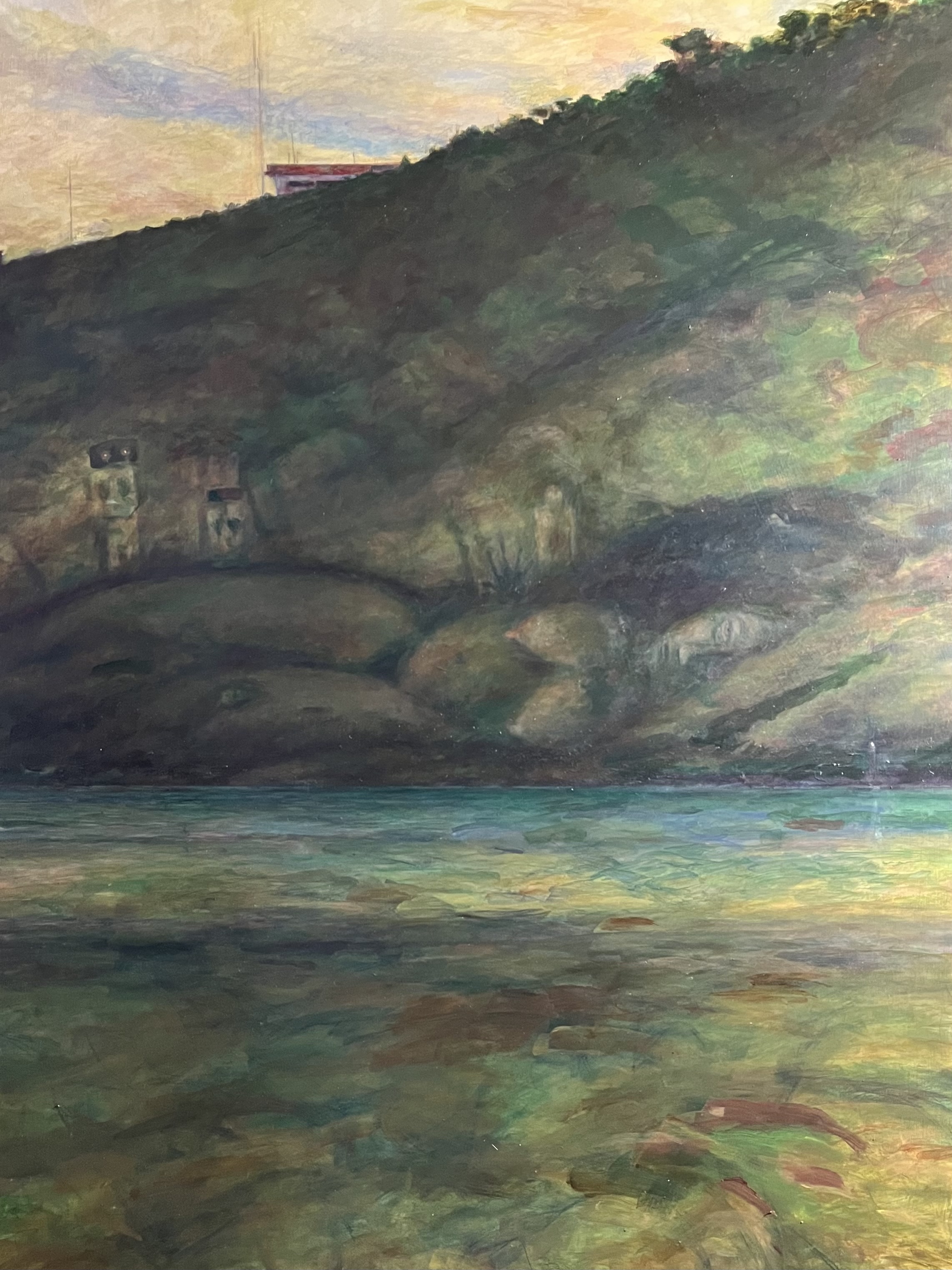
“The Stone Sisters and the Birthing Cave” by Artist Douglas Voorby
Long term Lake Macquarie resident and artist, Douglas Vooby, kindly sent us in this painting inspired by the historical accounts compiled above. The painting is titled “The Stone Sisters and the Birthing Cave.” He sent it by email on 5 December 2025.
Commentary
To the best of our knowledge, Threlkeld’s reporting of the significance of the site known as Mullungbula, including the detail of the site’s location, and the Aboriginal meaning to the original peoples – is the first documentation of a First Nations People’s Sacred Site by an Englishman in New South Wales.
The original descriptions to the site known as Mullungbula describe the area of Lake Macquarie now known as Green Point.
Mullungbula does not appear, from the early descriptions of Threlkeld and Walker to be Swansea Headland.
On page 153 of “Reid’s Mistake” Clouten quotes Threlkeld but omits or ignores from the quote the beginning that includes the location, e.g., ‘on the northern extremity of the eastern side of the lake’. Clouten then makes his first statement of the next paragraph in his book – “Mullung-bula is now the site of Swansea Heads”. Why is anyones’ guess?
Likewise Percy Haslam’s papers make the claim that Swansea Headland is the site of Mullungbula?
Why – if they read Gunson’s work on Threlkeld they would see the full description by Threlkeld and Walker.
It may be because of the 1887 break-wall works map by Coode.
Curiously, copies of this map have two rocks drawn and labelled as the “sisters” on the northern side of the headland.
But these rocks are located within the surf on the map, and a visit to the site confirms that there is nothing there but a rock shelf under water.
Haslam is correct about Swansea Headland being an important site.
There is a cave there that we have been told is a birthing cave; the headland has a deposit of white ochre; there is clear evidence of lithic work of the chert in the headland; and the site has petrified glosterop trees visible in the rock platform. It is also close to an occupation site that has been dated to 8,000 years BP.
Haslam is also correct that there is possible evidence the tessellated rock platform was used as a fish trap.
But the site doesn’t match the description and location given by Threlkeld and Walker. Yes, there is a visible coal seam at Swansea Headland, but it is up in the cliff face and it’s not very thick.
Threlkeld’s descriptions reported in the 1834 publication of the “Australian Grammar..” and in the 1855 Christian Herald provide the following information
- the two pillars are 9 feet high of conglomerate rock decaying fast
- they are below a bluff beneath a mountain on the margin (shore) of the lake (not at the entrance)
- the bluff and mountain are in the northern extremity of the lake on the eastern side
- a rich thick vein of coal can be seen on the shore below them
- this vein of coal continues to underwater and reappears at a point across the lake on the opposite shore
- this point on the opposite shore is called Munnukan
Walker’s visit to the old Mission site in 1836 (and Emeritus Professor John Fryer is correct in the identifying the site of the first mission as being on the hill on which the Gunyah Hotel stands at Belmont) reveals that:
- the location of the two upright rocks is a “little more than a gunshot from the mission ruins”
- a thick vein of coal can be seen on the shore which continues to the opposite shore
- Walker visits the site of the two pillars of stone and confirms they are the “objects of superstitious tradition among the Aborigines”
It is clear from Threlkeld and Walker’s accounts that Mullungbula was an important site for the Aboriginal People now referred to as the Awabakal.
The area now known as Green Point (which includes Cardiff Point) is visible from the site of the original Mission and is clearly little more than a gunshot north west from it. Green Point is a mountain on the eastern side of the northern part of the lake and would have been significantly higher prior to becoming a quarry for conglomerate stone; it does have a bluff and its coal seams and has been mined from the 1860’s to 1980’s; three coal seams – the Waratah, Great Northern and Fassifern seams – outcrop at various places around Green Point; the opposite shore from Green Point is Coal Point (which has that name for obvious reasons).
Threlkeld (in Gunson, 1974) reports that the site of Mullungbula was in the vicinity of where Captain Reid collected coal on his “discovery” of Lake Macquarie in 1800.
Threlkeld reports that he used the rock wharf built by Reid at this site, to land on the shore and inspect the two pillars of stone.
We’re not sure if there is any record of Captain Reid’s visit that describes the location he traveled to to collect the coal.
Perhaps historians have assumed he didn’t actually enter the Lake but collected coal from the cliff face of the Southern Headland (now known as Swansea Headland) – hence the location of Mullungbula being ascribed as Swansea Headland.
But it appears that he could hardly discover the Lake if he never went into it?

A number of photos – one is a view from Green Point back to the site in Belmont where the mission ruins would have stood.

One is a view west across the Lake to give you an idea of the height of the ‘mountain’ at Green Point.
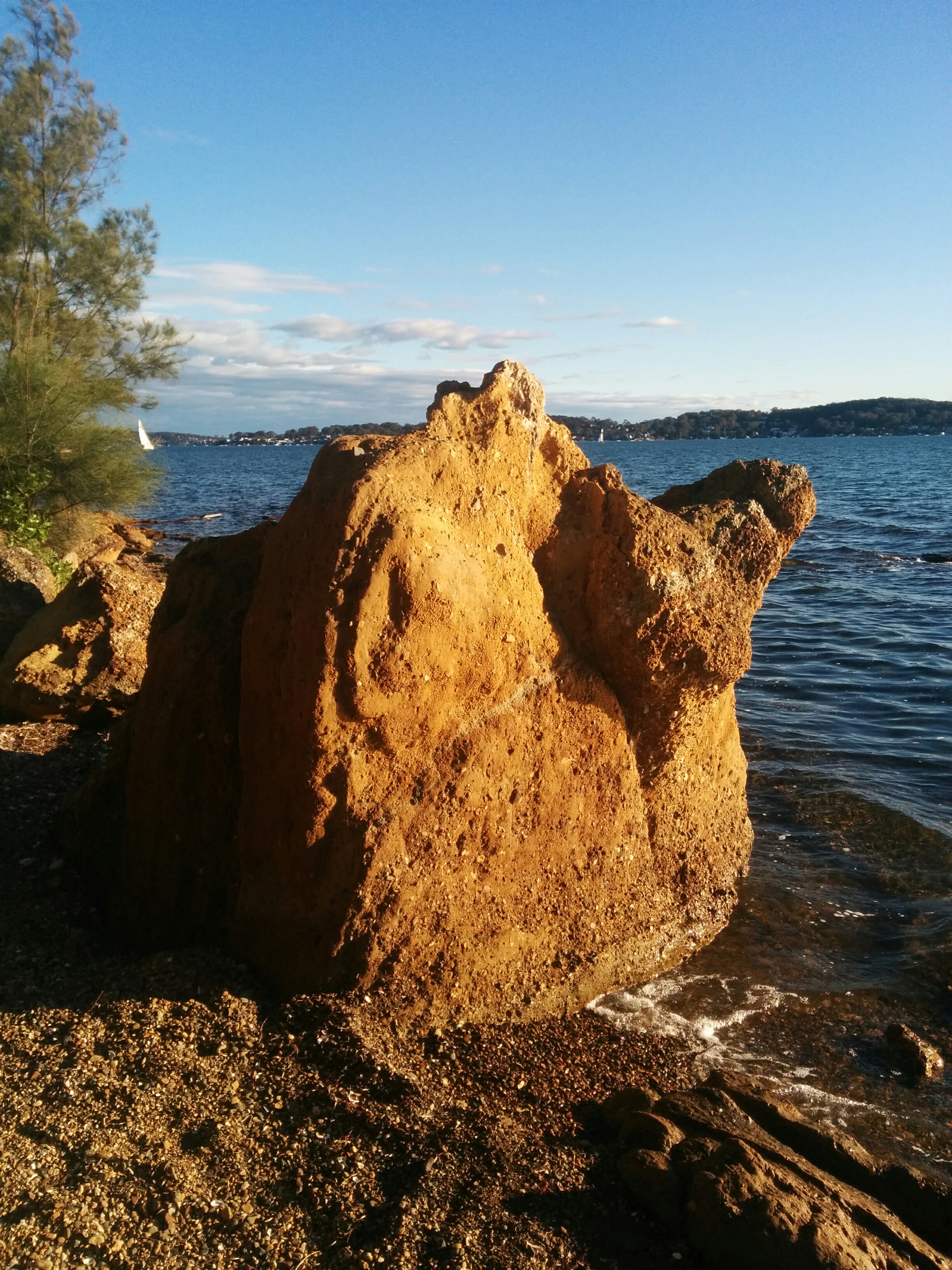
And one is a weathered ‘pudding-stone’ rock on the shore below the bluff at Green Point which may have been 9 foot tall once.
Moving the location of the site away from its original location to the northern shore of the southern headland of the entrance to the Lake – by putting it on a map drawn to improve colliery access for larger boats – could be the first documented time the N.S.W. Government has ignored the interest of its citizens to benefit the interests of the Mining Industry.
So why does Clouten say Mullungbula is Swansea Heads in his 1967 book, and why does Percy Haslam also agree?
It’s possible that it is all because of Coode’s map which has played a big part on changing what was originally described by Threlkeld.
Let us know what you think.
References
Clouten, Keith H. Reid’s Mistake: The story of Lake Macquarie from its discovery until 1890. Lake Macquarie Shire Council, 1967.
Gunson, N. Australian Reminiscences & Papers of L.E.Threlkeld: Missionary to the Aborigines 1824-1859 2 Vols.Canberra: Australian Institute of Aboriginal Studies, 1974.
Percy Haslam Papers. University of Newcastle Cultural Collections, especially:
A5410(i) Aboriginal myths and legends and other material relating to the Aborigines of Eastern New South Wales [Typescripts], 1977-1979
Threlkeld, L.E. An Australian Language as spoken by the Awabakal the people of Awaba and Lake Macquarie (Near Newcastle, New South Wales) being an account of their Language, Traditions, and Customs. Sydney: Charles Potter, Government Printer, 1892.
Gionni Di Gravio, OAM
University Archivist, & Chair, Hunter Living Histories
with generous assistance of a local researcher who wishes to remain anonymous.
There are 2 important questions to be answered here.
1. Where is the original sacred site of the Mullungbula?
2. Where is the original site where William Reid in the Martha took coals from?
Could the Rev Threlkeld be wrong about William Reid taking coals from this spot? He well could be but there is no doubt that Mullungbula is around Cardiff Point approximately. Looking from the first references given from Rev T and George Walker, they describe this place pretty accurately. Why does Keith Clouten and Lake Mac Council not recognize this, i am astonished by this ignorance. Mullungbula could of been relocated as indicated on Coode’s map, but this is only a plan. And why would they be taken away from their sacred spot and placed in the water at Swansea heads? Rev T was in this area around 1825, 25 years after Captain Reid came here. During this 25 year period there were hundreds of absconding convicts from Newcastle. I’m sure these coal seams were well known at Coal point and Cardiff point and could have been worked by privateers/convicts away from government eyes. The rock wharf built there seems unlikely Captain Reid’s work as he was led by the natives a short distance from the head according to David Collins. He mistook the place as Newcastle, loaded up once and nearly wrecked the Martha on the return journey. We could assume he took coals from Swansea heads as there is no accurate description or references relating to this. I really think there is a lot more to this story but unfortunately we might never know. Also Captain Reid was to meet the prisoners who had already of dug the coals for him, but they were not to be seen. You could just about be certain Captain Reid took the Martha through the channel looking for the prisoners and coal diggings, as he did not intend to dig them out himself. Lake Mac Council needs to have a good look at these early references and have a discussion and or debate about our local history. I would like to see some proof or solid information evidence on their conclusions on this topic.
An inlet to a lagoon or lake could be detected by high & low tides, fishing lines and shoals chased by sharks.