
[August 25, 2014 Update]
Please find updated post with new high resolution scans courtesy of Greg and Sylvia Ray here:
https://hunterlivinghistories.com/2014/08/25/newcastle-aerial-photos/
[August 2014 Update]
We contacted Mr Phillip Warren who was able to shed further light on the origin of the images.
The originals were held in the archives of the former A. Goninan & Co. Ltd. originally established in 1899, which later changed its name to United Goninan before being taken over by the United Group in 1999.
The company designs manufactures and undertakes maintenance work on railway rolling stock, locomotives and light rail vehicles.
Phillip arranged the original glass negatives to be re-scanned by Greg and Sylvia Ray. They have kindly provided us with the higher resolution files to assist in dating the images. We will upload as soon as we can.
Along with the digital files was a scan of an original listing of the glass negatives undertaken in 1988 by a J.L.N. Southern.
The original negatives were aerial photographs taken by Milton Kent Airplane Photographs, Sydney.
The title of the document is “Aerial Photographs of Port Hunter, Stockton, Newcastle, Carrington, Walsh Island, Port Waratah, Morandoo, Tirrikiba, Mayfield, Georgetown, Swansea Heads by Milton Kent Airplane Photographs, Sydney.”
It appears Southern was responsible for the numbering and dating of the images.
Original Post
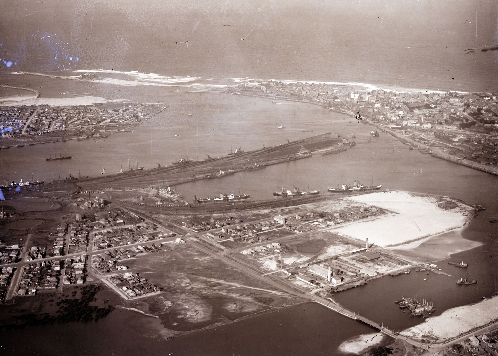
These aerial photographs were taken over Newcastle during the late 1920s, providing a bird’s eye view of the Newcastle landscape. We thank Phillip Warren for sharing these images with us.
Please click on the images to view the larger photographs.
We are always interested in people’s thoughts and comments, and any further information they wish to share. Please leave a comment in the box below the post.
We also thank Mr Russell Rigby for observing that there is no Newcastle Town Hall (dating the photographs to pre-1929) and Cathedral is under building scaffold for alterations (circa 1928). Dr Ann Hardy also relayed news from her son that the last photograph was of the Swansea Channel, rather than the Newcastle peninsula. Further comments and corrections are welcome.


Gionni Di Gravio
University Archivist, and Chair, Coal River Working Party
July 2014.
Damn it! Everything you do is so darn interesting. I wish I had more hours in my life to appreciate all your great work. Keep it up and I will keep cheering you on. Regards, Terry Gravolin
I think the tags have to be extended or revised to say “Newcastle 1920s” – the Town Hall clock tower (completed 1929) is not evident in any of the photos that cover that part of Newcastle.
Image 68 (dated1935) shows construction work on the nave of Christchurch – Barry Maitland in “Architecture Newcastle – a guide” refers to
the four arches of the crossing and the nave walls raised and roofed (1928).
Images of Nobbys Beach dated 1935 do not show the pavilion (opened 1934) and Shortland Esplanade around the foot of Fort Scratchley is incomplete. In addition there is no sign of the depression-era “Camp Shortland” at Horseshoe Beach.
Image 71 is of the then new Broadmeadow works of A. Goninan & Co. The railway lines to Waratah Colliery at Charlestown (the gully line0 & the line to (old) Lambton Colliery are in the foreground with the Waratah line being the closest (the site of the junction of the railway line to the original Waratah tunnel Collieries is also visible.
The photos, Image 68/13 and Image 68/14, show two buildings being constructed.
One building is the Dalgety Shipping Offices on the corner of Watt and King streets.
If you look you will see, Image 68/13, a “crane” on top of the building and also the lack of a facade.
Image 68/14 shows the building with a facade but work is still being done. Apparently the building was completed in 1927.
Also you can see in 68/13 the other building being erected on the corner of Scott and Hunter streets. This was until recently, last decade or so, a Commonwealth Bank branch. Again the two images show progress in connection with the construction of the building.
The Australian and NewZealand Bank on the corner of Brown and Hunter streets appears to be very new in appearance and the lack of a footpath, in Image 68/13, may demonstrate that the building is not yet open to the public.
According to an advertisement an optometrist relocated his business to this new building March 1927. Image 68/14 shows a new footpath in front of the bank which may indicate the building is open for business.
There is another building in the process of demolition shown in Image 68/13.
Image 68/14 shows construction on the same site being carried out.
I will let you find this site!
Just to narrow down any broader opinions as to the date of Images 68/13 and 14, the AMP Building was completed in 1925 and is visible. The Newcastle Herald Building was completed 1929/30 and is not visible in either photos.
Just for the record all of this information came from a tourist map not an academic education.
It would appear that the two images could be dated to between late 1926 and prior to March 1927. The photos could have been taken to show the growth in construction in the area as they appear to be before and after images. Just a theory.
The contracts for the new Dalgety and Co. Offices were signed 22 December 1926.
This would rule out 1926 as a possible year of the images creation.
The offices were opened 15 October 1927.
I would put money on the images being created between March and September 1927.
It may be possible to narrow the dates further.
Can anyone tell me more about a possible gasworks to the north of the current waratah village shopping center? also, would there be any aerial photography of the area from the 1920’s?
This map of Newcastle (in the Cultural Collection) https://flic.kr/p/aaXPrN compiled in 1910 by L/Cpl Barrett of the Royal Engineeers shows the gas works in the block surrounded by Turton Road, High St, and Georgetown Rd – with the firestation on the corner of High St and Turton Rd, The Waratah Village site was then a clay pit and brickworks.
Hi Russel, I don’t seem to be able to access the address you have listed, is there any other way of seeing the map?
Nathan,
according to newspaper articles on Trove, the Waratah Gas Works operated on the site on Turton Rd from 1889 till 1922, under the control of Waratah Municipal Council. The works were sold to Newcastle Gas and Coke Co in 1922, who then supplied gas from their Clyde St gasworks. The Waratah site buildings were advertised for sale & removal in 1928.
WARATAH GAS WORKS. (1922, April 11). Newcastle Morning Herald and Miners’ Advocate (NSW : 1876 – 1954) , , p. 4. http://nla.gov.au/nla.news-article140992378
Nathan, if you copy the address https://flic.kr/p/aaXPrN into your browser you should be able to get to the image on Flickr. The full url is for the map is:
https://www.flickr.com/photos/uon/6019950140/
Some work-places block access to sites like Flickr so you may also need to try from another computer.