Who is the “Giant” of Giant’s Leap?
By Leigh Budden
Warning to Aboriginal and Torres Strait Islander People:
This brief paper contains historical references to Aboriginal cultural practices ‒ but does not provide secret details about those ceremonies.
It mentions reference to historical articles that contain terms or views that were considered appropriate at the time in mainstream Australian Colonial culture and in the period that they were written but are no longer considered acceptable. These historical articles do not reflect the views of the University or the author.
It also contains names of Aboriginal People who are deceased.
The author pays respect to all Aboriginal Elders, past, present, and emerging, and fully recognises and honours their intellectual property, knowledge, and traditions.
Dawn in the Valley and the Gamilaraay People
I first became aware of the Gamilaraay People occupying the Upper Hunter Valley at the time of colonial contact in the 1820’s and 30’s when I read W. Allan Wood’s 1972 historical publication titled Dawn in the Valley.
Tribute to W. Allan Wood
I had attended Dr Mark Dunn’s book launch of his 2020 book titled “The Convict Valley” and at this presentation Dr Dunn mentioned the significant work Wood had done on both colonial history of the Hunter Valley, and his extensive research into the Aboriginal People at the time of British settlement of the Hunter Valley. This settlement was via the large land grants made to colonists by the British Government in the 1820’s and 30’s.
Allan Wood’s research papers are held in the Archives of Special Collections and is an excellent resource – see https://hunterlivinghistories.com/2020/05/06/wood-papers/
“Dawn in the Valley” Author Walter Allan Wood Research Papers
Aboriginal and Settler Relationships
In “Dawn of the Valley” Wood included references to the experiences of settler families who had positive interaction with the Gamilaraay People who occupied the Valley from around Denman up to the plains around modern Merriwa; and lived around the upper Hunter, Goulburn and Pages rivers. He also included historical references to the massacres, murders and destruction of this Aboriginal population over two generations.
On page 12 Wood’s describes how in 1819 John Howe, the then Magistrate and senior constable at Windsor arrived at Doyles Creek near (modern day) Jerry Plains. Miles, his Aboriginal companion and guide described the country as
“all that was Comery Roy, and a more farther, a great way”
Wood describes settler references to the names ‘Comnaroy’, ‘Coomilary Roy’, ‘Comleroy’, ‘Comilaroi’ and ‘Kumleroy’ as describing the Aboriginal People of the Upper Hunter. This includes a moving quote from Edward Ogilvie’s 1856 diary that mentions the warrior Coolan and several of the ‘Camilarrai’ Mobs in the valley.
The Diary of Edward Olgilvie
Edward Olgilvie was a son of William Olgilvie. In 1825 William received a land grant of 6,000 acres on the banks of the Goulburn and Hunter Rivers and established the estate of Merton near modern day Denman. On page 46 and 47 of Edwards Diary of Travels Volume One, Edward recorded a return visit home to Merton, camping at Scone on the way, and a chance meeting with someone from his boyhood…
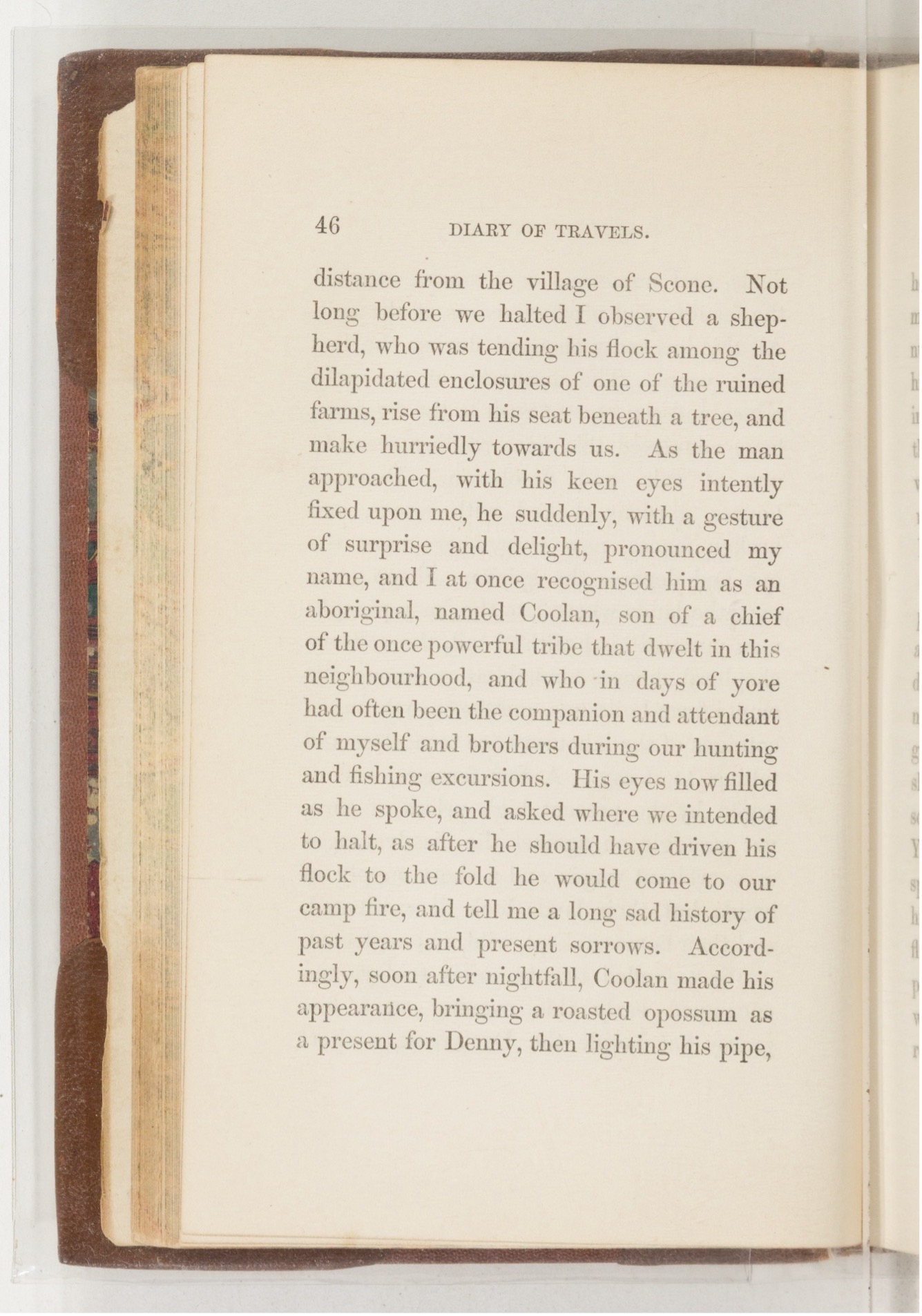
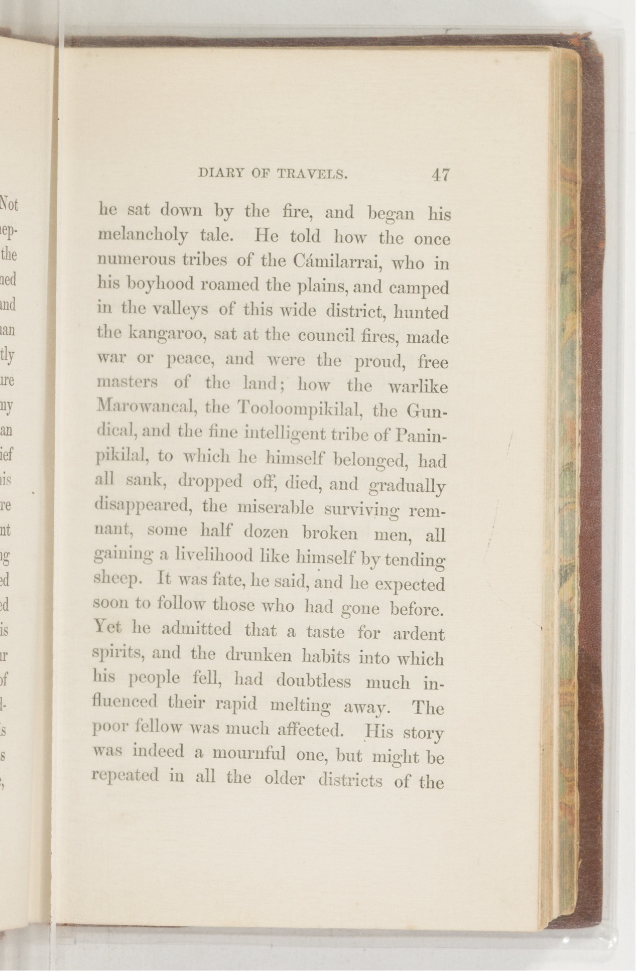
(P.46) Not long before we halted I observed a shepherd, who was tending his flock among the dilapidated enclosures of one of the ruined farms, rise from his seat beneath a tree, and make hurriedly towards us. As the man approached, with his keen eyes intently fixed upon me, he suddenly, with a gesture of surprise and delight, pronounced my name, and I at once recognised him as an aboriginal, named Coolan, son of a chief of the once powerful tribe that dwelt in this neighbourhood, and who in days of yore had often been the companion and attendant of myself and brothers during our hunting and fishing excursions. His eyes now filled as he spoke, and asked where we intended to halt, after he should have driven his flock to the fold he would come to our camp fire, and tell me a long sad history of past years and present sorrows. Accordingly, soon after nightfall, Coolan made his appearance, bringing a roasted opossum as a present for Denny, and lighting his pipe, (P.47) he sat down by the fire and began his melancholy tale. He told how the once numerous tribes of the Cámilarrai, who in his boyhood roamed the plains, and camped in the valleys of this wide district, hunted the kangaroo, sat at the council fires, made war or peace, and were the proud, free masters of the land; how the warlike Marowancal, the Tooloompikilal, the Gundical, and the fine intelligent tribe of Paninpikilial, to which he himself belonged, had all sank, dropped off, died, and gradually disappeared, the miserable surviving remnant, some half dozen broken men, all gaining a livelihood like himself by tending sheep. It was fate, he said, and he expected soon to follow those who had gone before. Yet he admitted that a taste for ardent spirits, and the drunken habits into which his people fell, had doubtless much influenced their rapid melting away. The poor fellow was much affected. His story was indeed a mournful one, but might be repeated in all the old districts…”
In his 1833 book Excursions in New South Wales, Western Australia and Van Dieman’s Land during the years 1830, 1831, 1832 and 1833, William Henry Breton wrote of the land and people of the Upper Hunter Valley, recording Aboriginal place names and commenting on the country of the Gummun Plains (now Merriwa district). He wrote that the land had the appearance of being cultivated and ploughed.
This is similar to Sir Thomas Mitchell’s observations in Volume One of Three expeditions into the interior of eastern Australia : with descriptions of the recently explored region of Australia Felix, and of the present colony of New South Wales but Breton goes on to refer to the Aboriginal People of the Upper Hunter as ‘Gammon Comleroy’ and the Aboriginal People of the Liverpool Plains as the ‘Corborn Comleroy’.
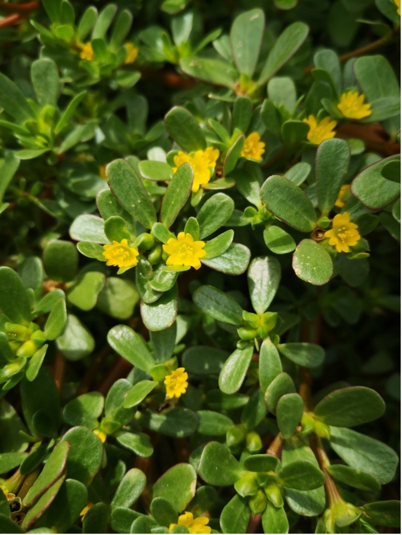
Breton claims ‘Gammon’ means small, and ‘Corborn’ implies great (see Chapter 2 page 2). But this is Breton’s corruption of the Gamilaraay words ‘Ghanan’ and ‘Gaabiin’.
Ghanan is the word for portulaca oleracea – a succulent ground cover with yellow buttercup flowers that is a Gondwanaland plant and important bush tucker. Breton comments on the fields being covered in yellow buttercups which is likely a reference to the cultivation of ghanan by the Gamilaraay People of the Upper Hunter. Gaabiin is the word for the Carbeen Tree – eucalyptus tessellaris – which is common on the Liverpool Plains and is important for bush medicine and weapon manufacturing.

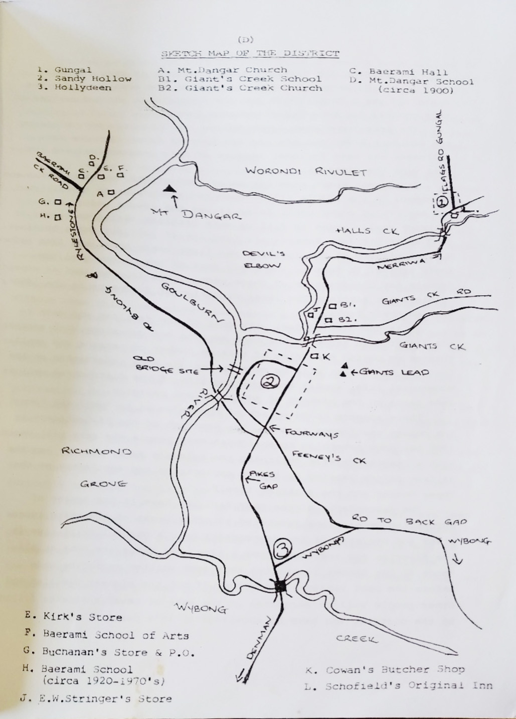
Origin of the locality name Baerami
Another very interesting thing in W. Allan Wood’s book was his speculation around the origin of the name of the locality Baerami which is on the Goulburn River, not far from modern Sandy Hollow township in the Upper Hunter Valley.
On page 147 Wood’s wrote:
“The name Baerami is only slightly different from Bai-ame, and I do not doubt it is the same. Assistant Surveyor Rogers wrote the name Baerami creek on a map in 1829… Baerami could have been the native name of the locality, of the creek, or the conspicuous lone mountain opposite its mouth”.
Assistant Surveyor John Rogers was tasked by his boss – the Surveyor General Sir Thomas Mitchell – to survey and map the Goulburn River area in the Hunter Valley. Rogers spent twelve months doing this from June 1829. Would he have been told the sacred name of the Creation Ancestor as an uninitiated man? It’s unlikely that his Aboriginal guide and informant would have done so. Perhaps it’s another word altogether and a mistake to link it to a sacred word? It might be possible that Rogers recorded the meaning of Baerami in his Survey Field book?
I managed to track down the 1970 book A History of Baerami Creek Valley by Ian Ellis and in the introduction on page 5 it reads:
“the tribes of aborigines occupying the Goulburn and some of the north-west belonged to a virile and powerful nation of tribes named the Kamerleroi, who had an interesting belief. They believed there was a great god who lived in the sky who spoke when it thundered. His name was ‘Baiami’ (pronounced Bay-a-me). The valley was named in his honour, and when the white man came, the name continued as Baerami – literally God’s land. ‘Baerami’ originally applied to the station property which finally included almost the whole of Baerami creek valley”
I also found a 1980’s publication by Geoffrey I. Meyer titled In the shadow of Mount Dangar: A history of Sandy Hollow, Gungal, Hollydene and Baerami. In it he writes that:
“Mount Dangar, the tallest peak in the area dominates the scene, and was the focal point for the Aboriginals who had resided in this country for some forty thousand years” (page 1).
And on page 3:
“The tribes of the Kamilaroi nation of which the Marawancal tribe (or the Ogilvie Blacks as they were known) was one who lived in the district; were highly intelligent people with a belief in a single higher being and a strict code of conduct”
There are historical records that,
“the blacks – as many as 1,000 – congregating in the neighbourhood of Mount Dangar” and “within living memory, engraved trees marking former sacred grounds stood at the foot of Mount Dangar”.
Meyer included a sketch of the area, including Mt Dangar, Devil’s Elbow and Giants Leap.
(See Maitland Weekly Mercury (NSW : 1894 – 1931), Saturday 6 June 1896, page 13 for a description of “as many as 1000 blacks congregating at times in the neighbourhood of Mt Dangar”) – Among the Pastoralists and Producers. (1896, June 6). The Maitland Weekly Mercury (NSW : 1894 – 1931), p. 13. Retrieved December 4, 2025, from http://nla.gov.au/nla.news-article132402833
I also found a reference to Giants Leap and the Devil’s Elbow in a newspaper article published in the Maitland Mercury and Hunter River General Advertiser (NSW : 1843 – 1893), Saturday 31 July 1880, page 2, titled ‘A trip to Cassilis’.
In it the author refers to:
“Giants leap, a most singular formed gap in the mountain – said by the blacks to have been made by their Evil One in a leap over the mountains” and “A few miles further the Devil’s Elbow – evil one again.”

This 1880 article also mentions the columnar basalt outcrops at Battery Rock rest area, a few kilometres north of Gungal. – A Trip to Cassilis. (1880, July 31). The Maitland Mercury and Hunter River General Advertiser (NSW : 1843 – 1893), p. 2 (Second Sheet of The Maitland Mercury). Retrieved December 4, 2025, from http://nla.gov.au/nla.news-article811037
And the Marawancal – now written as Mara-wan-gal?
This is made up of the Gamilaraay words ‘mara’ which means hand, forearm, the verb “to give”, or the number ‘5’. “wan” is a clitic that adds to a noun as a suffix to denote ‘big or significant’. And ‘gal’ means ‘group or mob’.
Is it possible that the Marawangal Mob who occupied this district were literally ‘of the big hand’?
So, what of Mount Dangar at Baerami?
Originally surveyed by Henry Dangar in 1824 and named Mount Cupola, it was renamed by Alan Cunningham in 1825 who climbed the basalt peak and named it Mount Dangar.
Dangar’s 1828 map of the Hunter River showing Mount Dangar and Giant’s Leap.
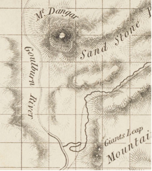
But on the Surveyor General Thomas Mitchell’s 1834 map it is recorded by its Aboriginal name –Warandie and on subsequent County maps as Mt. Worondi which is the Englishification of Warandie.

Sounds and Meanings
Given that Warandie is a Gamilaraay word it is possible to recognise the surveyors attempt to capture the Aboriginal informant’s pronunciation. The clue is in the ‘die’ suffix.
I am confident that the word is made up of a verb and a suffix that converts a verb to a noun in Gamilaraay. That is, the word Warandie is actually Wara-ndie.
‘Wara’ is the verb “to start, stand up, begin,” and the suffix ‘ndaay’ (which follows a verb ending in an ‘a’) is phonetically pronounced like English ‘n-die’.
The Aboriginal name for what today is called Mount Dangar is actually a noun and it means ‘the beginning; the start’. In Gamilaraay, ‘wara’ (now written ‘warra’) also is used in words to describe strength and power, spirits and the milky way. ‘Wara’ also describes something that is straight, vertical or standing up
Mitchell’s 1834 map includes ‘Giants Creek’ but makes no mention of ‘Giant’s Leap’.
I think that it is possible that Mount Warandie (Mount Dangar – Warra-ndaay) was a very significant place for the Gamilaraay of the Upper Hunter Valley.
It lies with the Goulburn National Park but close up views of the mountain are possible via Worondi Road at Gungal. It is a no-through road, but according to the Gungal Community page at https://gungal.org/gungal/ it affords superb views of the Mountain.
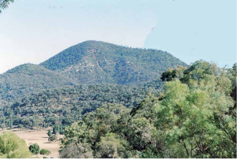
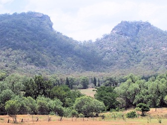
The “Giant” of Giant’s Leap
I guess we will never know the Dreamtime significance of Warrandaay as a geological feature of this spectacularly beautiful part of the Hunter Valley. But the shape of the mountain from this angle does remind me of a giant asleep on their side. Maybe others can see that too? Or is it just my imagination?
Maybe with a big hand resting beside his head as well?
I mean no disrespect to the Gamilaraay People, but I wonder if this sleeping giant is the ‘Giant’ of Giant’s Leap. The creator of the gap in the mountain behind Sandy Hollow and perhaps who was being referred to in the 1880 newspaper article as ‘the Evil One’?
It’s interesting that this same 1880 newspaper article referred to the columnar basalt at Battery Rock on Worondi Creek as possibly having a relationship with the creator of Giant’s Leap.
Thought to be 30 million years old there is not a lot of historical information on this site. The local council did quarry the rock until making it a reserve in 1931 (see Muswellbrook Chronicle (NSW: 1898 – 1955), Friday 16 October 1931, page 2)
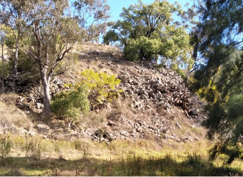

I did find a reference from W. J. Enright (Mankind, March 1932 pp 75-77) of a columnar basalt stone circle in the Hunter Valley that was reported as a ceremonial site by the Magistrate at Cassilis in the 1850’s.
Could this have referred to the Battery Rock site at Gungal, a short distance from Mount Warrandaay? (Mt Dangar / Mt Warandie)
Maybe, but I guess we will never know? But I think the two outcrops look like Dreamtime Bigibilla burrowing into the side of the hills in search of ants, i.e. two giant porcupines (Echidnas). The columnar basalt are their quills as seen from behind – but maybe it’s just my imagination…
Ngaya yalagirrmaga winangay Gamilaraay marigalagaa.
Ngarrangarrali gurumayuu
Leigh Budden
3 December 2025
One thought on “Who is the “Giant” of Giant’s Leap? Sandy Hollow New South Wales”