This work is conducted in memory and respectfully honours the First Australian People,
the Aboriginal People of this land.
The Origin of Terra Nullius from Cook’s Own Words
The Doctrine of Discovery and Terra Nullius.
“On the 20 August 1770 Lieutenant Jame Cook proclaimed the east coast of the continent a British possession. The concept of terra nullius, or land belonging to no-one, remained the legal principle on which British colonisation rested until 1992, when the High Court brought down its finding in the Mabo vs Queensland (No. 2) case. It ruled that the lands of the continent were not terra nullius at the time of settlement” (Ref: NLA)
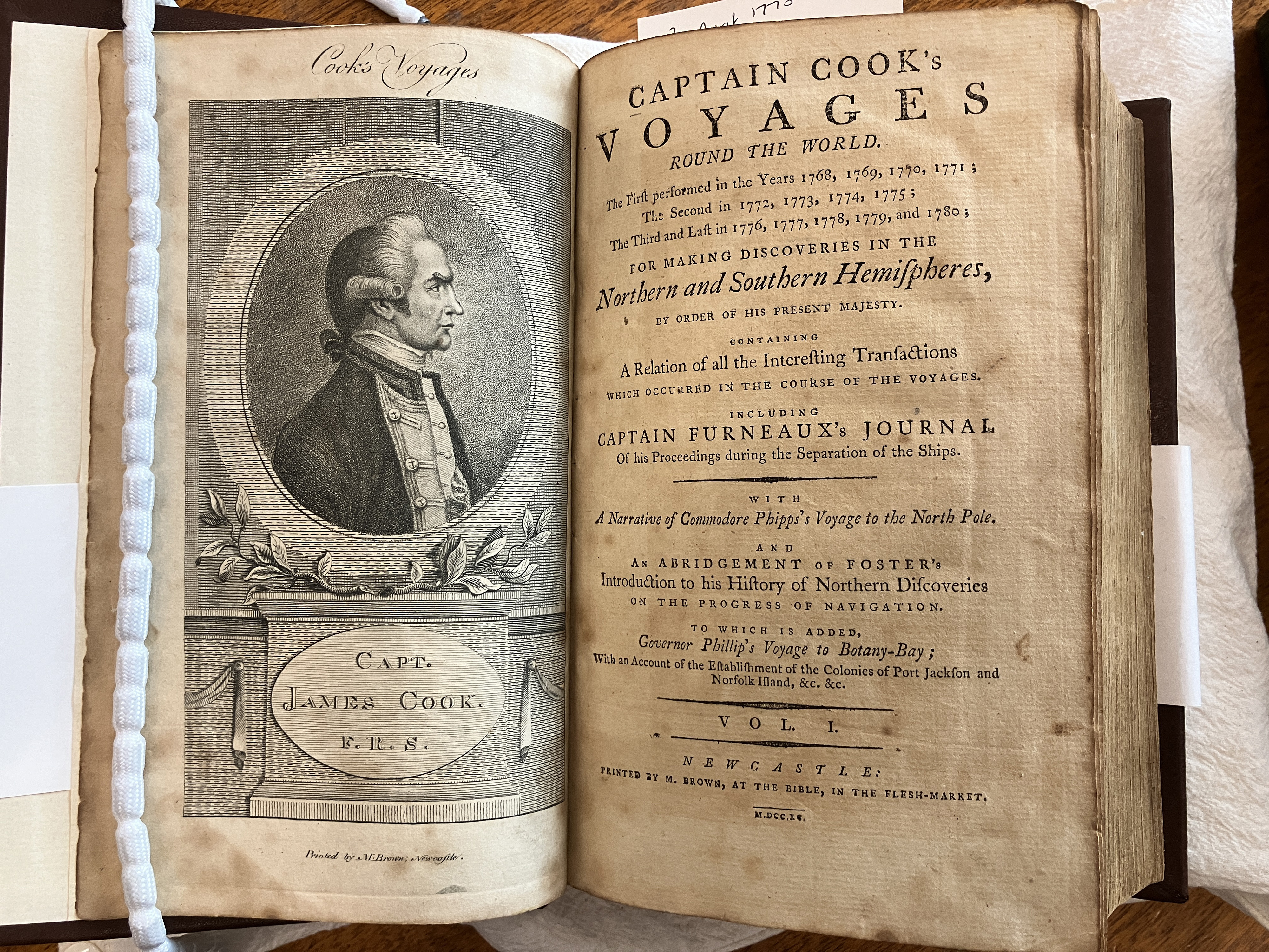
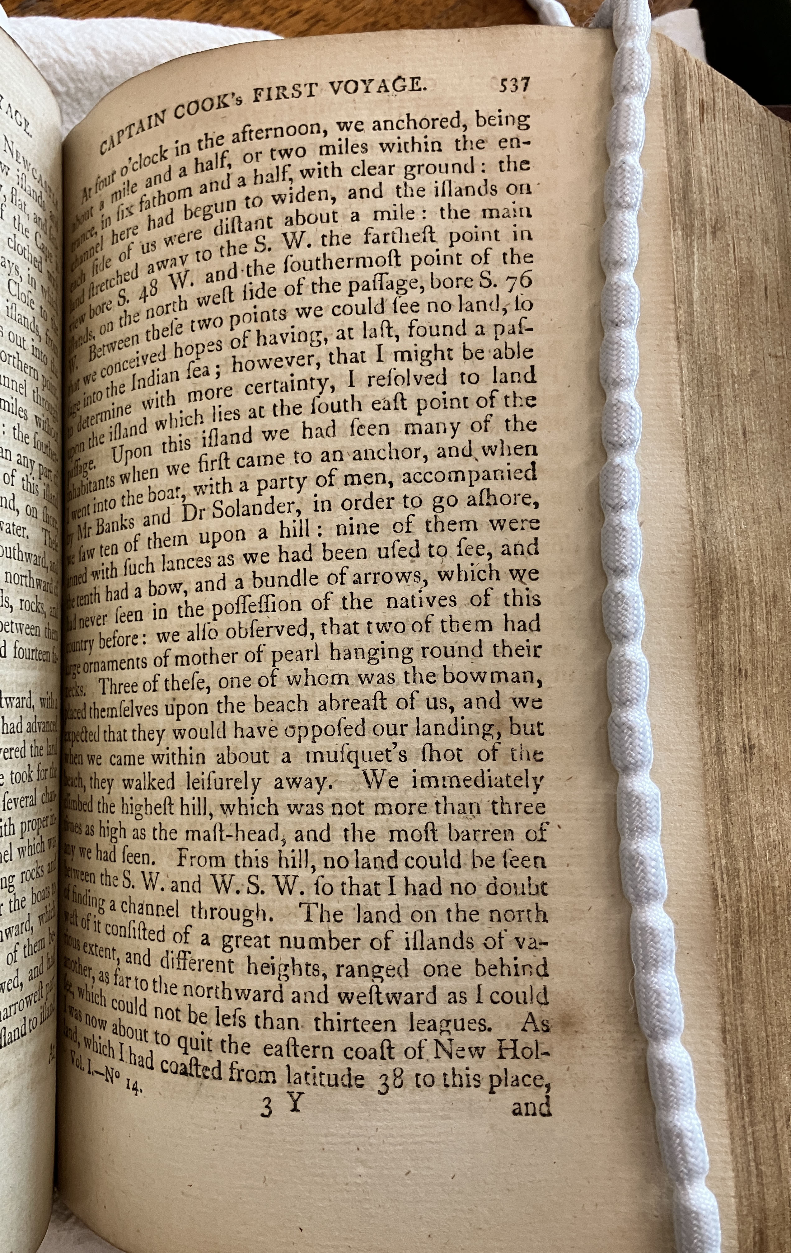
Captain Cook’s Voyage Round the World… (1790)
Read Lieutenant (later Captain) Cook’s words that began the idea of “Terra Nullius” from Captain Cook’s Voyage Round the World… (1790) Vol. 1 No. 14 p. 537-538. These words are recorded by Cook as occurring on the 21 August 1770, whereas it is recorded in the National Library as being “20 August 1770”. This being caused by the method that naval officers reckoned the day as beginning at 12 noon, and not 12 midnight as land dwellers do.
“Upon this island we had seen many of the inhabitants when we first came to an anchor, and when I went into the boat, with a part of men, accompanied by Mr banks and Dr Solander, in order to go ashore, we saw ten of them upon a hill: nine of them were armed with such lances as we had been used to see, and the tenth had a bow, and bundle of arrows, which we had never seen in the possession of the natives of this country before: we also observed, that two of them had large ornaments of mother of pearl hanging round their necks. Three of these, one of whom was the bowman, placed themselves upon the beach abreast of us, and we expected that they would have opposed our landing, but when we came within about a musquet’s shot of the beach, they walked leisurely away. We immediately climbed the highest hill, which was not more than three times as high as the mast-head, and the most barren of any we had seen. From this hill, no land could be seen between the S.W. and W.S.W. so that I had no doubt of finding a channel through. The land on the north west of it consisted of a great number of islands of various extent, and different heights, ranged one behind another, as far to the northward and westward as I could see, which could not be less than thirteen leagues. As I was now about the quit the eastern coast of New Holland, which I had coasted from latitude 38 to this place, and which I am confident no European had even seen before, I once more hoisted English colours, and though I had already taken possession of several particular parts, I now took possession of the whole eastern coast, from latitude 38 d. to this place, latitude 10 ½ S. in right of his Majesty King George the Third, by the name of NEW SOUTH WALES, with all the bays, harbours, rivers, and islands situated upon it: we then fired thee vollies of small arms, which were answered by the same number from the ship. Having performed tis ceremony upon the island, which we called POSSESSION ISLAND, we reembarked in our boat, but a rapid ebb tide setting N.E. made our return to the vessel very difficult and tedious.”

A Note on Naval Time versus Civil Time
“When Joseph Banks recorded events in his journal, he used civil time, meaning that each day begins at midnight. So 10 am comes before 2 pm on the same day. However, in the eighteenth century, naval officers used nautical or ship’s time rather than civil time. Ship’s time means that each day begins at noon. So 2 pm comes before 10 am. Hence, Cook’s journal entries begin with the events of the afternoon, followed by midnight, followed by those of the morning, and end with noon.” – Civil Time, Ship’s Time and the Date Line by Ian Boreham (Editor)
The Words from Lieutenant Cook’s Original Holograph Journal (August 1770)
To confuse matters, it appears from Cook’s Journal entries for August 1770 held at the National Library of Australia and transcribed by the National Museum Australia located here: https://www.nma.gov.au/exhibitions/endeavour-voyage/cooks-journal/august-1770 that the words were actually uttered on (his) “22nd August 1770” (our) “21st August 1770”.
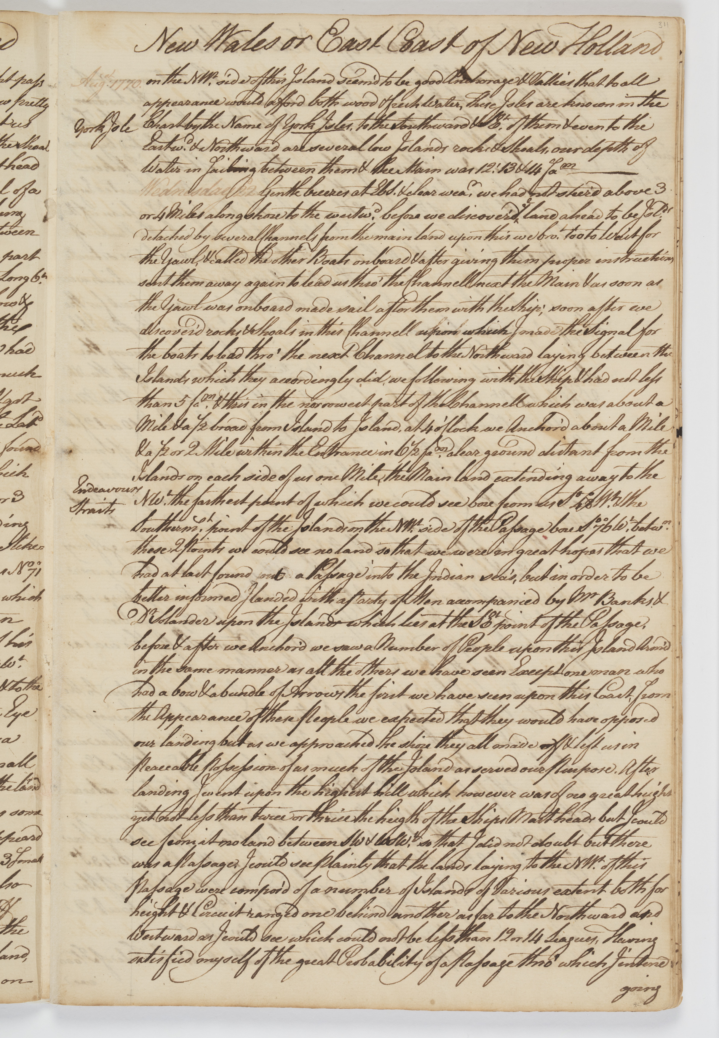
Wednesday 22 August 1770
Wednesday 22d Gentle breezes at EBS and clear weather. We had not stood above 3 or 4 Miles along shore to the westward. before we discover’d the Land ahead to be Islands detach’d by several channells from the Main land, upon this we brought too to wait for the yawl and called the other boats on board, and after giving them proper Instructions sent them away again to lead us through the Channell next the Main, and as soon as the yawl was on board made sail with the Ship after them;
soon after we discoverd Rocks, & shoals in this Channell upon which I made the Signal for the boats to lead through the next Channel to the Northward laying between the Islands which they accordingly did we following with the Ship and had not less than 5 fathom water and this
wasin the narrowest part of the Channell which was about a Mile and a half broad from Island to Island.At 4 oClock we anchor’d about a Mile and a half or 2 Miles within the entrance in 6½ fathom clear ground distant from the Islands on each side of us one mile, the Main
dland extending away to the SW, the farthest point of which that we could see bore from us St 48° West and the South-wester-most point of the Islands on the NW side of the Passage bore St 76° West between these two points we could see no land so that we were in great hopes that we had at last found out a Passage into theinto theIndian seas, but in order to be better informd I landed with a party of Men accompan’d by Mr Banks and Dr Solanderand landupon the Island which lies at the SE point of the Passage:before and after we
landedAnchor’d we saw a number of People upon this Island arm’d in the same — manner as all the others we have seen except one man who had a bow and a bundle of Arrows the first we have seen on this coast. from the appearence of these People we expected they would have opposed our landing but as we approached the Shore they all made off and left us in peaceable posession of as much of the Island as served our purpose.After landing I went upon the highest hill which however was of no great height, yet not less than twice or thrice the height of the Ships Mast heads but I could see from it no land between SW and WSW so that I did not doubt but there was a passage, I could see plainly that the Lands laying to the NW of this passage were composed of a number of Island of various extent both for height and circuit rainged one be hind a nother as far to the Northward and Westward as I could see which could not be less than 12 or 14 Leagues.
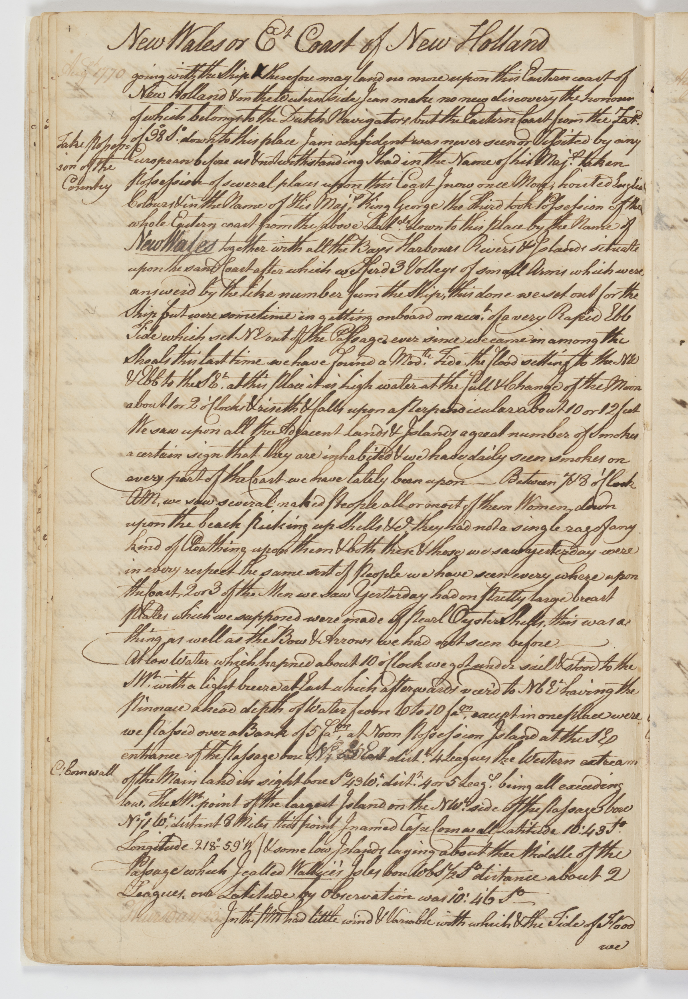
Having satisfied myself of the great Probabillity of a Passage, thro’ which I intend going with the Ship and therefor may land no more upon this
WesternEastern coast of New Holland and on the Western side I can make no new discovery the honour of which belongs to the Dutch Navigatorsand as such they may lay claim to it as their propertybut the Eastern Coast from the Latitude of 38° South down to this place I am confident was never seen or viseted by any European before us andtherefore by the same Rule belongs to great BrittanNotwithstand I had in the Name of his Majesty taken posession of several places upon this coast I now once more hoisted English Coulers and in the Name of His Majesty King George the Third took posession of the whole Eastern Coast from the above Latitude down to this place by the Name of New South Wales together with all the Bays, Harbours Rivers and Islands situate upon thesamesaid coast after which we fired three Volleys of small Arms which were Answerd by the like numberbyfrom the Shipthis done we set out for the Ship but were some time in geting on board on accout of a very rappid Ebb Tide which set NE out of the Passage
away to the NEever sence we came in among the Shoals this last time we have found a Moderate Tide the Flood seting to the NW and Ebb to the SE. at this place it is High-water at the Full and Change of the Moon about 1 or 2 o’Clock and riseth and falls upon a perpendicular about 10 or 12 feet.We saw on all the Adjacent Lands and Islands a great number of smooks a certain sign that they are Inhabited and we have dayly seen smooks on every part of the coast we have lately been upon — Between 7 and 8 oClock in the Morning we saw several naked people, all or most of them women, down upon the beach picking up Shells, &Ca they had not a single rag of any kind of Cloathing upon them and both these and those we saw yesterday were in every respect the Same sort of people we have seen every where upon the Coast; two or three of the Men we saw Yesterday had on pretty large breast plates which we supposed were made of Pearl Oysters Shells this was a thing as well as the Bow and Arrows we had not seen before —
At Low-water which happend about 10 oClock we got under sail and stood to the SW with a light breeze at East which afterwards veerd to NBE, having the Pinnace a head, depth of water from 6 to 10 fathom except in one place where we pass’d over a bank of 5 fathom —
At Noon Posession Island at the SE entrance of the Passage bore N 53° East distant 4
MilesLeagues the western extreme of the Main land in sight bore St 43° West distant 4 or 5 Leagues, being all exceeding low, The SW point of the largest Island on the NW side of the Passage bore No 71° West distant 8 Miles this point I named Cape Cornwell / Latd 10°..43′ S: Longde 219°..0 and some Low Islands laying about the Middle of the Passage which I call’d Wallice’s Isles — bore WBS ½ S distt about 2 Leagues, our Latitude by Observation was 10°.46′ South —
Wednesday 22 August 1770 from the Endeavour Journal (SLNSW)
“At 6 Possession was taken of this Country ” – from Log of H.M.S. Endeavour 1768-1770 [Manuscript] (Courtesy NLA)
“At 6 Possession was taken of this Country in his Majesty’s Name [?] and this was announc’d from the shore by firing vollies and answered from the ship with Colours flying: the whole concluding with 3 cheers.”
!["At 6 Possession of this Country was taken" -from Log of HMS Endeavour 1768-1770 [Manuscript] (Courtesy NLA)](https://hunterlivinghistories.com/wp-content/uploads/2024/08/At-6-Took-Possession-from-Log-of-HMS-Endeavour-1768-1770-Manuscript.jpg)
Possible Implications for New Zealand
Within the National Archives of the United Kingdom lies a file CO 700/ New South Wales 16/ that was very useful in that it contained the original 1801 Barrallier chart of Hunter’s River. But when examined physically by Dr Ann Hardy in 2010, was also found to contain original records relating to New Zealand as well. This was due to the fact that New Zealand was also part of what was understood to be “NEW SOUTH WALES”, which is the name that Lieutenant Cook took possession of the Country between those two latitudes.
So, the question we ask is: Is our origin of “terra nullius” in Cook’s words also that for New Zealand as well?
Gionni Di Gravio OAM
University Archivist & Chair, Hunter Living Histories
When the Endeavour reached Batavia, they became aware that they had crossed the date line and thus made amendments to the ships log and Cooks journal. There is some suggestion that other amendments were made concerning place names and facts. Beaglehole remains the best source. SLNSW holds the ‘Corner copy’, a copy of Cook’s journal made by his clerk Orton. Apparently the corner copy contains some small errors.
“Terra nullius” does not appear to be words that Cook used….