

Here are two digital copies of G.B White’s 1844 Plan of the Hunter Region from the Port Hunter (Newcastle) to the Maitland Falls.
Title
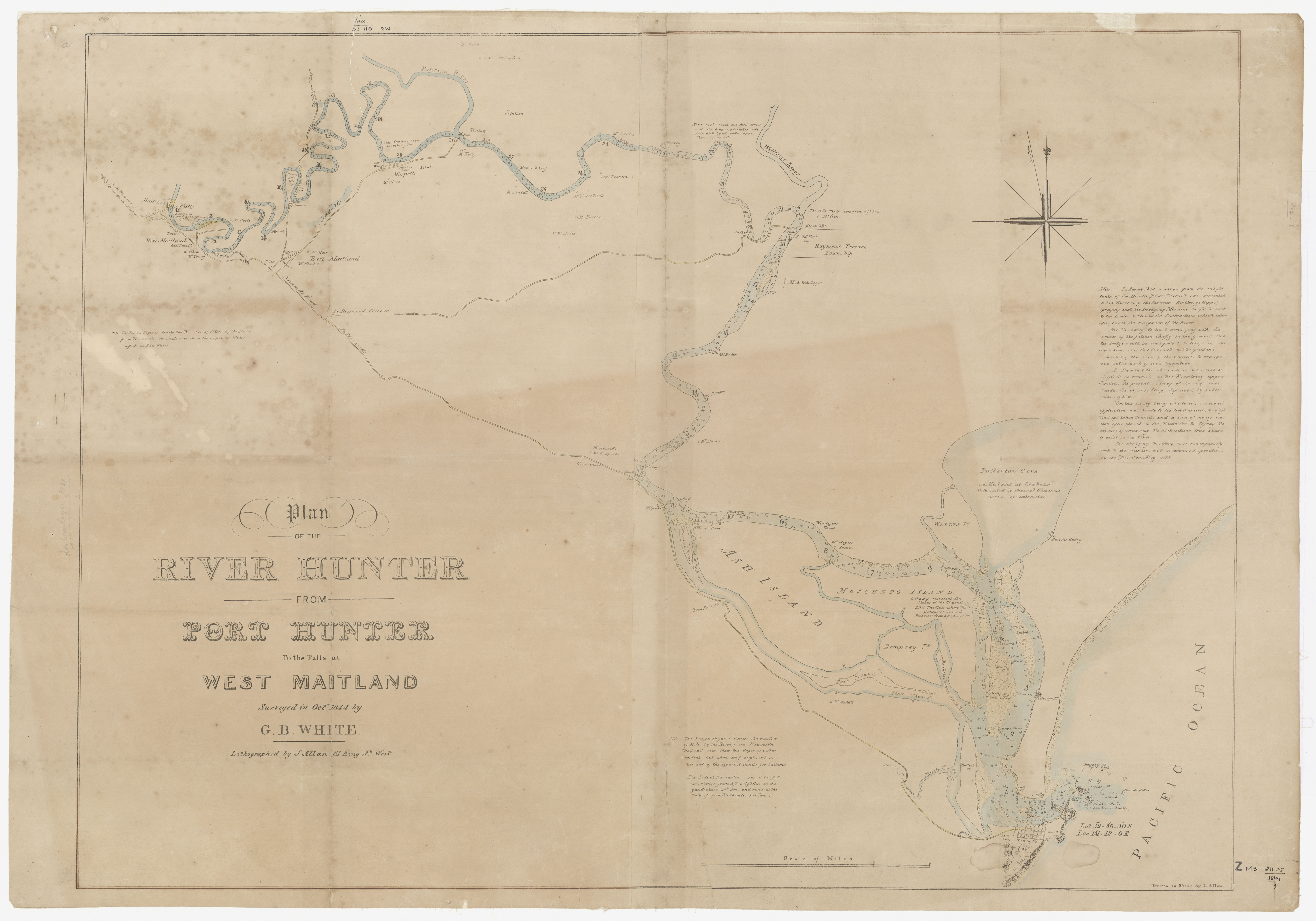
Plan of the River Hunter from Port Hunter to the Falls at West Maitland Surveyed in October 1844 by G.B White. Lithographed by J. Allen 81 King St. West.

1844 Plan – Notes
Note. In August 1844 a petition from the inhabitants of the Hunter River District was presented to his Excellency the Governor (Sir George Gipps) praying that the Dredging Machine might be sent to the Hunter to remove the Obstructions which interfered with the navigations of the River.
His Excellency declined complying with the prayer of the petition, chiefly on the grounds that the dredge would be inadequate to so large an undertaking, and that it would not be prudent, considering the state of the revenue, to engage in a public work of such magnitude.
To show that the obstructions were not so difficult of removal as His Excellency apprehended, the present survey of the river was made, the expense being defrayed by public subscription.
On this survey being completed, a second application was made to the Government, through the Legislative Council, and a sum of money was soon after placed on the Estimates to defray the expense of removing the obstructions thus shown to exist in the river.
The dredging machine was consequently sent to the Hunter, and commenced operations on the Flats in May 1845.
1844 Plan – Notes Relating to Figures
[Left hand Side] NB. The Large Figures denote the Number of Miles by the River from Newcastle, the Small Ones show the depth of water in feet at Low Water.
[Base] NB. The Large Figures denote the Number of Miles by the River from Newcastle. The Small Ones show the depth of water, but when an f is placed at the end of the figure it stands for Fathoms.
The Tide at Newcastle rises at the full and change from 5 ft. to 4 ft. 5 in. at the quadrature 3 ft. 9in. and runs at the rate of from 2 to 2 1/2 miles per hour.
[At right hand base] Drawn on Stone by J. Allan
1844 Plan – Geographical and Built Environment Features
Newcastle and Coastline
- Newcastle
- A.A. Co. Works [Australian Agricultural Company Works]
- Gaol
- Break Water
- Nobby Island
- Outside Roller 5f
- A wash
- Sunken Rocks Sea Breaks heavily
- Outside of the Oyster bank
Stockton
- [Stockton] Cloth Fy (Cloth Factory)
- [Stockton] Salt Wk (Salt Works)
- [To the North of Stockton] Georges R (?)
- [To the North of Stockton] Smith’s Dairy
Inner Harbour, Port of Newcastle and Hunter Estuary
- [Shoal] Dry at Low Water
- [Shoal] Dry at Low Water
- Bullock Island
- Throsby Creek
- Heap of Stones
- Partly dry at Low Water
- Spectacle Island
- Stones
- Dry at Low Water
- Survey Island
- Dry at Low water
- Snapper Island
- Fullerton Cove. A Mud Flat at Low water intersected by Several Channels more or less extensive.
- Wallis Island
- Partially Dry
- Windeyers Drain
- Windeyers Wharf
- Moscheto Island. o w z x y represents the Stakes of the Channel. ABC The flats where the Steamers Ground. Tide rises from 4 ft 9 to 3 ft 9 in.
- Dempsey Island
- Moscheto Channel South Branch
- Spit Island
- Platts Channel
- Platts Mill
- Ash Island
- A.W. Scott
- Barn
- South Channel of the Hunter
- Hexham Island
- Iron bark Creek
- W.S. Sparks
- [On North side] Wharf
- North Channel
- Rocks
Hunter River
- Wharf
- Wharf
- Punt
- Rocks
- Mr Dacre
- Drain
- Mr Bretts
- Mr A. Windeyer
Raymond Terrace
- Raymond Terrace Township
- Mr Harts Inn
- Rock
- Punt
- Steam Mill
- The Tide Rises Here from 4 ft. 6 in. to 3 ft. 6 in.
- Williams River
- Ship Yards
- These rocks reach one third across and stand up in pinnacles with from 4 1/2 to 5 feet water upon them at Low water
- Mr Hickey
- Rocks
- Mr Castles
- Rocks
- Captain Pearson
- Mr. Eales’ Dock, Mr. Pearce, Mr. Eales, Mr. Bendall
- Manns Wharf
- Rock
Hinton
- Mr Kelly
- Punt
- Rock
- Mr Dillon
- Paterson River
- Captain Livingston
- Dr Scott (?)
Morpeth
- Morpeth
- School
- Anlabys Inn
- Punt
- Government Wharf
- Mr Close
- Tide rises here from 4 ft 3 in to 3 ft 3 in
- Lagoon
Road towards Maitland
- Wheat Sheaf Inn
- Woodlands. Mr E. Sparks
- Parsonage
- Newcastle Road. To Newcastle
- [Road] To Raymond Terrace
East Maitland
- Mr. Muir, Mr. Mayo, Mr. Keddie, Mr. Cox
- Wallis Creek
- Mitchell
- Punt Pitnacreee
- [Road] To Paterson Village
- Rise of Tide 3 ft to 2 ft
- Mr Doyle
West Maitland
- Mr Dougel
- Rise of Tide from 2 ft [?] to 1 ft 8in
- Mr Young
- Mr Cohen
- Captain Russell
- West Maitland
- Reeves
- Punt
- Yeomans
- Long Bridge
- To the Wolombi and Upper Hunter Districts
Maitland Falls
Click here for more posts on the Region’s Mapping and Plans
Gionni Di Gravio, OAM
University Archivist & Chair, Hunter Living Histories